You are here: Home > Network List > UU - University of Utah Regional Network Stations List
> Station FOR3 Blundell North, UT, USA > Earthquake Result Viewer
FOR3 Blundell North, UT, USA - Earthquake Result Viewer
| Earthquake location: |
Peru-Ecuador Border Region |
| Earthquake latitude/longitude: |
-2.2/-77.0 |
| Earthquake time(UTC): |
2019/02/22 (053) 10:17:22 GMT |
| Earthquake Depth: |
132 km |
| Earthquake Magnitude: |
7.5 mww |
| Earthquake Catalog/Contributor: |
NEIC PDE/us |
|
| Network: |
UU University of Utah Regional Network |
| Station: |
FOR3 Blundell North, UT, USA |
| Lat/Lon: |
38.51 N/112.88 W |
| Elevation: |
1699 m |
|
| Distance: |
52.3 deg |
| Az: |
324.486 deg |
| Baz: |
132.274 deg |
| Ray Param: |
0.06641982 |
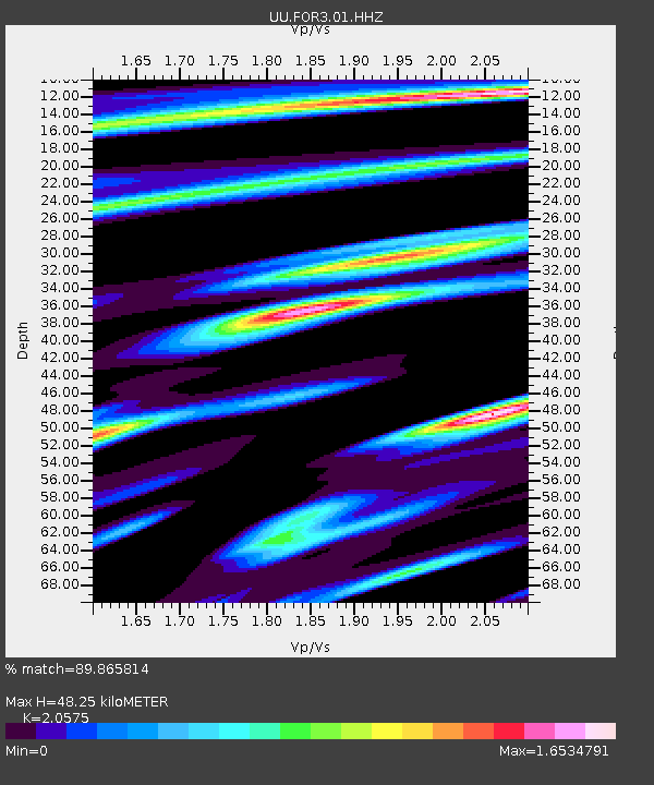
| Estimated Moho Depth: |
48.25 km |
| Estimated Crust Vp/Vs: |
2.06 |
| Assumed Crust Vp: |
6.276 km/s |
| Estimated Crust Vs: |
3.05 km/s |
| Estimated Crust Poisson's Ratio: |
0.35 |
|
| Radial Match: |
89.865814 % |
| Radial Bump: |
400 |
| Transverse Match: |
76.202126 % |
| Transverse Bump: |
400 |
| SOD ConfigId: |
3313551 |
| Insert Time: |
2019-03-08 10:28:49.960 +0000 |
| GWidth: |
2.5 |
| Max Bumps: |
400 |
| Tol: |
0.001 |
|

Signal To Noise
| Channel | StoN | STA | LTA |
| UU:FOR3:01:HHZ:20190222T10:25:49.679989Z | 16.55364 | 8.112687E-8 | 4.9008473E-9 |
| UU:FOR3:01:HHN:20190222T10:25:49.679989Z | 2.673179 | 2.665238E-8 | 9.970294E-9 |
| UU:FOR3:01:HHE:20190222T10:25:49.679989Z | 4.93442 | 3.7582087E-8 | 7.616313E-9 |
| Arrivals |
| Ps | 8.5 SECOND |
| PpPs | 22 SECOND |
| PsPs/PpSs | 31 SECOND |


