You are here: Home > Network List > IW - Intermountain West Stations List
> Station MOOW Moose Ponds, Wyoming, USA > Earthquake Result Viewer
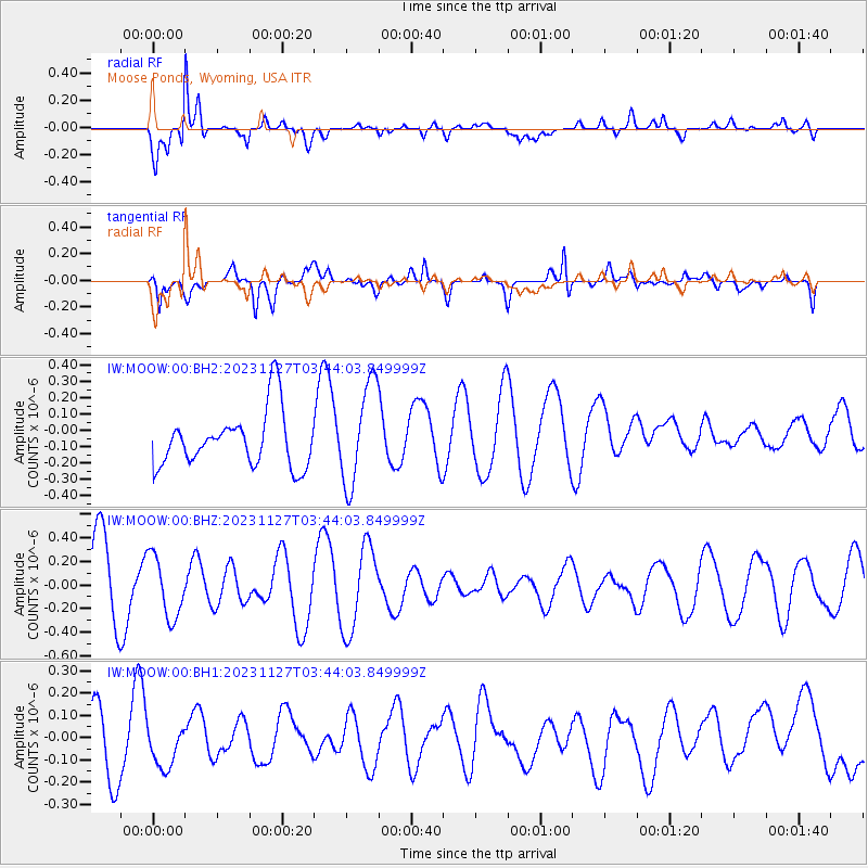
MOOW Moose Ponds, Wyoming, USA - Earthquake Result Viewer
*The percent match for this event was below the threshold and hence no stack was calculated.
| Earthquake location: |
Vanuatu Islands Region |
| Earthquake latitude/longitude: |
-21.0/173.9 |
| Earthquake time(UTC): |
2023/11/27 (331) 03:31:16 GMT |
| Earthquake Depth: |
10 km |
| Earthquake Magnitude: |
5.5 Mww |
| Earthquake Catalog/Contributor: |
NEIC PDE/us |
|
| Network: |
IW Intermountain West |
| Station: |
MOOW Moose Ponds, Wyoming, USA |
| Lat/Lon: |
43.75 N/110.74 W |
| Elevation: |
2128 m |
|
| Distance: |
94.3 deg |
| Az: |
44.677 deg |
| Baz: |
245.011 deg |
| Ray Param: |
$rayparam |
*The percent match for this event was below the threshold and hence was not used in the summary stack. |
|
| Radial Match: |
79.81001 % |
| Radial Bump: |
400 |
| Transverse Match: |
57.68667 % |
| Transverse Bump: |
400 |
| SOD ConfigId: |
33182351 |
| Insert Time: |
2023-12-11 03:45:12.495 +0000 |
| GWidth: |
2.5 |
| Max Bumps: |
400 |
| Tol: |
0.001 |
|
Signal To Noise
| Channel | StoN | STA | LTA |
| IW:MOOW:00:BHZ:20231127T03:44:03.849999Z | 1.031043 | 2.602122E-7 | 2.5237765E-7 |
| IW:MOOW:00:BH1:20231127T03:44:03.849999Z | 0.54623073 | 1.0331232E-7 | 1.8913677E-7 |
| IW:MOOW:00:BH2:20231127T03:44:03.849999Z | 1.8341529 | 3.1206292E-7 | 1.7014007E-7 |
| Arrivals |
| Ps | |
| PpPs | |
| PsPs/PpSs | |


