You are here: Home > Network List > TA - USArray Transportable Network (new EarthScope stations) Stations List
> Station G21A Lodge Grass, MT, USA > Earthquake Result Viewer
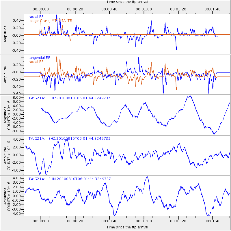
G21A Lodge Grass, MT, USA - Earthquake Result Viewer
*The percent match for this event was below the threshold and hence no stack was calculated.
| Earthquake location: |
Off East Coast Of Honshu, Japan |
| Earthquake latitude/longitude: |
39.4/143.1 |
| Earthquake time(UTC): |
2010/08/10 (222) 05:50:37 GMT |
| Earthquake Depth: |
22 km |
| Earthquake Magnitude: |
5.8 MB |
| Earthquake Catalog/Contributor: |
WHDF/NEIC |
|
| Network: |
TA USArray Transportable Network (new EarthScope stations) |
| Station: |
G21A Lodge Grass, MT, USA |
| Lat/Lon: |
45.22 N/107.21 W |
| Elevation: |
1227 m |
|
| Distance: |
74.7 deg |
| Az: |
43.623 deg |
| Baz: |
310.858 deg |
| Ray Param: |
$rayparam |
*The percent match for this event was below the threshold and hence was not used in the summary stack. |
|
| Radial Match: |
68.20751 % |
| Radial Bump: |
386 |
| Transverse Match: |
67.89863 % |
| Transverse Bump: |
400 |
| SOD ConfigId: |
319893 |
| Insert Time: |
2011-01-05 19:39:41.743 +0000 |
| GWidth: |
2.5 |
| Max Bumps: |
400 |
| Tol: |
0.001 |
|
Signal To Noise
| Channel | StoN | STA | LTA |
| TA:G21A: :BHZ:20100810T06:01:44.324973Z | 3.1315343 | 4.008938E-6 | 1.2801833E-6 |
| TA:G21A: :BHN:20100810T06:01:44.324973Z | 0.5601401 | 6.787054E-7 | 1.2116709E-6 |
| TA:G21A: :BHE:20100810T06:01:44.324973Z | 1.1056213 | 2.498857E-6 | 2.260138E-6 |
| Arrivals |
| Ps | |
| PpPs | |
| PsPs/PpSs | |


