You are here: Home > Network List > TA - USArray Transportable Network (new EarthScope stations) Stations List
> Station L26A Underwood Farm, Alliance, NE, USA > Earthquake Result Viewer
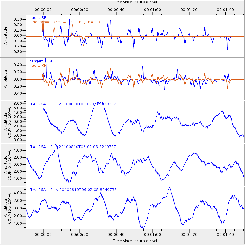
L26A Underwood Farm, Alliance, NE, USA - Earthquake Result Viewer
*The percent match for this event was below the threshold and hence no stack was calculated.
| Earthquake location: |
Off East Coast Of Honshu, Japan |
| Earthquake latitude/longitude: |
39.4/143.1 |
| Earthquake time(UTC): |
2010/08/10 (222) 05:50:37 GMT |
| Earthquake Depth: |
22 km |
| Earthquake Magnitude: |
5.8 MB |
| Earthquake Catalog/Contributor: |
WHDF/NEIC |
|
| Network: |
TA USArray Transportable Network (new EarthScope stations) |
| Station: |
L26A Underwood Farm, Alliance, NE, USA |
| Lat/Lon: |
42.04 N/103.08 W |
| Elevation: |
1248 m |
|
| Distance: |
79.1 deg |
| Az: |
43.969 deg |
| Baz: |
313.776 deg |
| Ray Param: |
$rayparam |
*The percent match for this event was below the threshold and hence was not used in the summary stack. |
|
| Radial Match: |
33.536575 % |
| Radial Bump: |
314 |
| Transverse Match: |
52.285095 % |
| Transverse Bump: |
293 |
| SOD ConfigId: |
319893 |
| Insert Time: |
2011-01-05 19:40:13.135 +0000 |
| GWidth: |
2.5 |
| Max Bumps: |
400 |
| Tol: |
0.001 |
|
Signal To Noise
| Channel | StoN | STA | LTA |
| TA:L26A: :BHZ:20100810T06:02:08.824973Z | 0.82539785 | 1.8897226E-6 | 2.2894687E-6 |
| TA:L26A: :BHN:20100810T06:02:08.824973Z | 0.63325953 | 1.5933398E-6 | 2.5160928E-6 |
| TA:L26A: :BHE:20100810T06:02:08.824973Z | 3.1611223 | 9.203994E-6 | 2.9116222E-6 |
| Arrivals |
| Ps | |
| PpPs | |
| PsPs/PpSs | |


