You are here: Home > Network List > TA - USArray Transportable Network (new EarthScope stations) Stations List
> Station 631A Perdido Creek Ranch, Del Rio, TX, USA > Earthquake Result Viewer
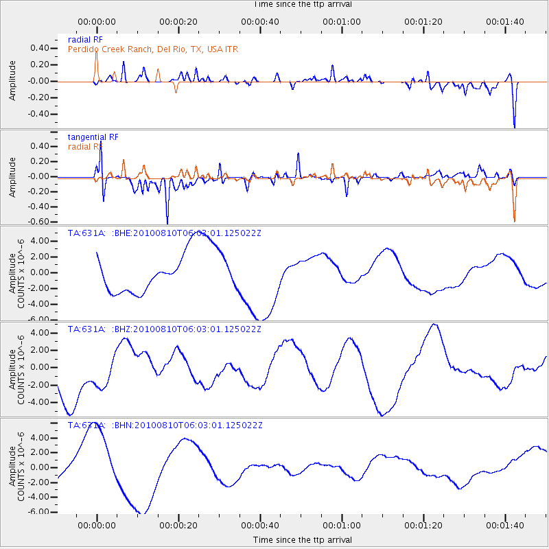
631A Perdido Creek Ranch, Del Rio, TX, USA - Earthquake Result Viewer
*The percent match for this event was below the threshold and hence no stack was calculated.
| Earthquake location: |
Off East Coast Of Honshu, Japan |
| Earthquake latitude/longitude: |
39.4/143.1 |
| Earthquake time(UTC): |
2010/08/10 (222) 05:50:37 GMT |
| Earthquake Depth: |
22 km |
| Earthquake Magnitude: |
5.8 MB |
| Earthquake Catalog/Contributor: |
WHDF/NEIC |
|
| Network: |
TA USArray Transportable Network (new EarthScope stations) |
| Station: |
631A Perdido Creek Ranch, Del Rio, TX, USA |
| Lat/Lon: |
29.41 N/100.58 W |
| Elevation: |
344 m |
|
| Distance: |
89.4 deg |
| Az: |
51.48 deg |
| Baz: |
315.994 deg |
| Ray Param: |
$rayparam |
*The percent match for this event was below the threshold and hence was not used in the summary stack. |
|
| Radial Match: |
56.736393 % |
| Radial Bump: |
400 |
| Transverse Match: |
55.05251 % |
| Transverse Bump: |
310 |
| SOD ConfigId: |
319893 |
| Insert Time: |
2011-01-05 19:41:05.087 +0000 |
| GWidth: |
2.5 |
| Max Bumps: |
400 |
| Tol: |
0.001 |
|
Signal To Noise
| Channel | StoN | STA | LTA |
| TA:631A: :BHZ:20100810T06:03:01.125022Z | 0.56789756 | 1.7908468E-6 | 3.1534682E-6 |
| TA:631A: :BHN:20100810T06:03:01.125022Z | 3.7030897 | 4.5715315E-6 | 1.2345181E-6 |
| TA:631A: :BHE:20100810T06:03:01.125022Z | 0.9475965 | 2.2809215E-6 | 2.4070598E-6 |
| Arrivals |
| Ps | |
| PpPs | |
| PsPs/PpSs | |


