You are here: Home > Network List > TA - USArray Transportable Network (new EarthScope stations) Stations List
> Station 133A Hamilton Ranch, Breckenridge, TX, USA > Earthquake Result Viewer
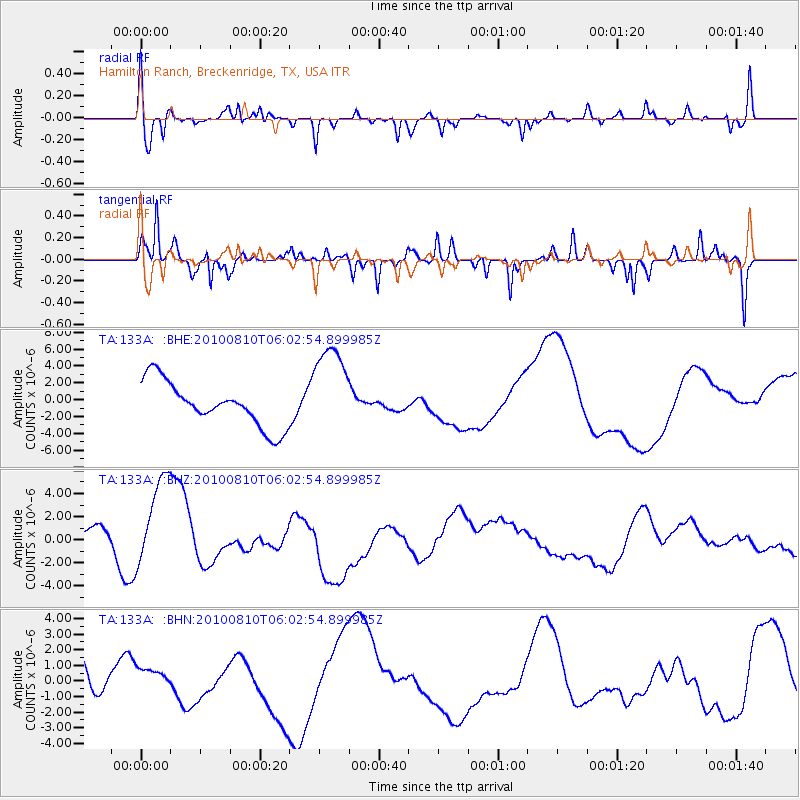
133A Hamilton Ranch, Breckenridge, TX, USA - Earthquake Result Viewer
*The percent match for this event was below the threshold and hence no stack was calculated.
| Earthquake location: |
Off East Coast Of Honshu, Japan |
| Earthquake latitude/longitude: |
39.4/143.1 |
| Earthquake time(UTC): |
2010/08/10 (222) 05:50:37 GMT |
| Earthquake Depth: |
22 km |
| Earthquake Magnitude: |
5.8 MB |
| Earthquake Catalog/Contributor: |
WHDF/NEIC |
|
| Network: |
TA USArray Transportable Network (new EarthScope stations) |
| Station: |
133A Hamilton Ranch, Breckenridge, TX, USA |
| Lat/Lon: |
32.61 N/98.92 W |
| Elevation: |
418 m |
|
| Distance: |
88.1 deg |
| Az: |
48.25 deg |
| Baz: |
316.777 deg |
| Ray Param: |
$rayparam |
*The percent match for this event was below the threshold and hence was not used in the summary stack. |
|
| Radial Match: |
35.259808 % |
| Radial Bump: |
314 |
| Transverse Match: |
42.237457 % |
| Transverse Bump: |
230 |
| SOD ConfigId: |
319893 |
| Insert Time: |
2011-01-05 19:42:12.280 +0000 |
| GWidth: |
2.5 |
| Max Bumps: |
400 |
| Tol: |
0.001 |
|
Signal To Noise
| Channel | StoN | STA | LTA |
| TA:133A: :BHZ:20100810T06:02:54.899985Z | 2.096803 | 4.2464735E-6 | 2.0252135E-6 |
| TA:133A: :BHN:20100810T06:02:54.899985Z | 0.72315764 | 8.9468364E-7 | 1.2371903E-6 |
| TA:133A: :BHE:20100810T06:02:54.899985Z | 2.1461809 | 5.640478E-6 | 2.6281466E-6 |
| Arrivals |
| Ps | |
| PpPs | |
| PsPs/PpSs | |


