You are here: Home > Network List > UU - University of Utah Regional Network Stations List
> Station TCRU Three Creek Reservoir, UT, USA > Earthquake Result Viewer
TCRU Three Creek Reservoir, UT, USA - Earthquake Result Viewer
| Earthquake location: |
Peru-Ecuador Border Region |
| Earthquake latitude/longitude: |
-2.2/-77.0 |
| Earthquake time(UTC): |
2019/02/22 (053) 10:17:22 GMT |
| Earthquake Depth: |
132 km |
| Earthquake Magnitude: |
7.5 mww |
| Earthquake Catalog/Contributor: |
NEIC PDE/us |
|
| Network: |
UU University of Utah Regional Network |
| Station: |
TCRU Three Creek Reservoir, UT, USA |
| Lat/Lon: |
38.61 N/112.45 W |
| Elevation: |
2293 m |
|
| Distance: |
52.1 deg |
| Az: |
324.866 deg |
| Baz: |
132.776 deg |
| Ray Param: |
0.066542506 |
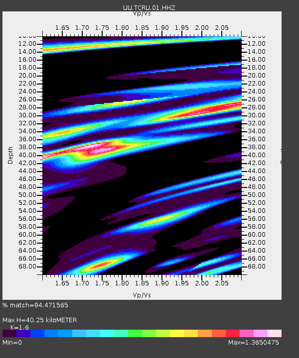
| Estimated Moho Depth: |
40.25 km |
| Estimated Crust Vp/Vs: |
1.60 |
| Assumed Crust Vp: |
6.276 km/s |
| Estimated Crust Vs: |
3.922 km/s |
| Estimated Crust Poisson's Ratio: |
0.18 |
|
| Radial Match: |
94.471565 % |
| Radial Bump: |
400 |
| Transverse Match: |
85.94552 % |
| Transverse Bump: |
400 |
| SOD ConfigId: |
3313551 |
| Insert Time: |
2019-03-08 10:29:20.616 +0000 |
| GWidth: |
2.5 |
| Max Bumps: |
400 |
| Tol: |
0.001 |
|

Signal To Noise
| Channel | StoN | STA | LTA |
| UU:TCRU:01:HHZ:20190222T10:25:48.309994Z | 27.338535 | 1.059265E-7 | 3.874623E-9 |
| UU:TCRU:01:HHN:20190222T10:25:48.309994Z | 4.789529 | 2.4624628E-8 | 5.1413465E-9 |
| UU:TCRU:01:HHE:20190222T10:25:48.309994Z | 6.2020526 | 3.5276557E-8 | 5.687884E-9 |
| Arrivals |
| Ps | 4.1 SECOND |
| PpPs | 16 SECOND |
| PsPs/PpSs | 20 SECOND |


