You are here: Home > Network List > TA - USArray Transportable Network (new EarthScope stations) Stations List
> Station U35A Pawnee, OK, USA > Earthquake Result Viewer
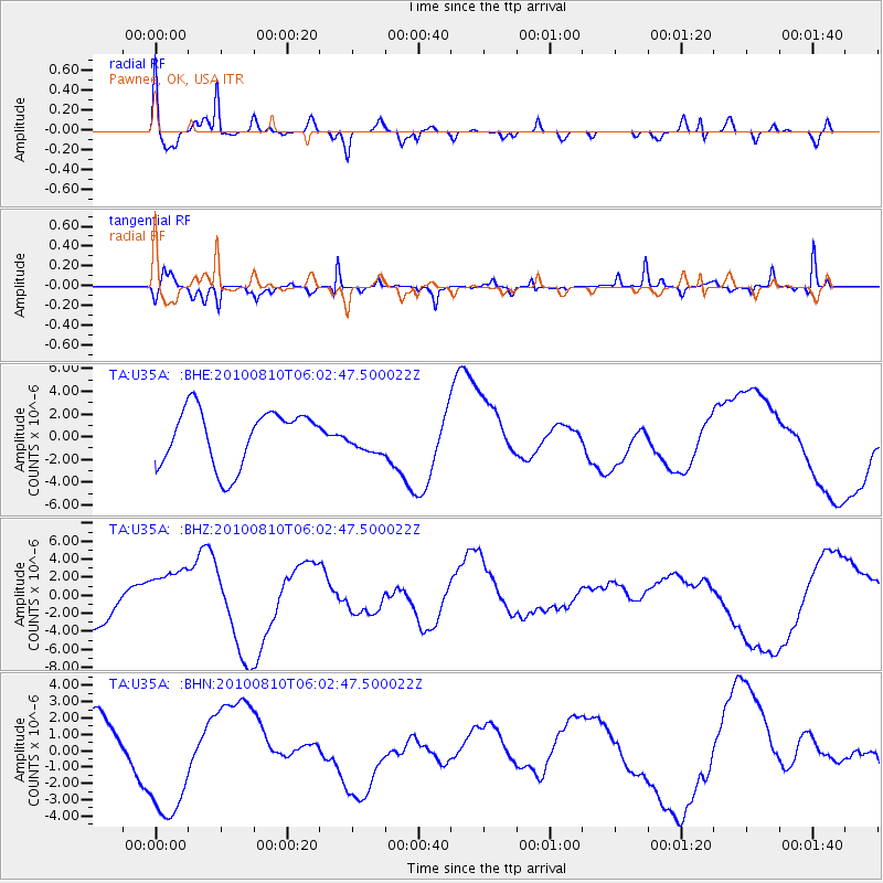
U35A Pawnee, OK, USA - Earthquake Result Viewer
*The percent match for this event was below the threshold and hence no stack was calculated.
| Earthquake location: |
Off East Coast Of Honshu, Japan |
| Earthquake latitude/longitude: |
39.4/143.1 |
| Earthquake time(UTC): |
2010/08/10 (222) 05:50:37 GMT |
| Earthquake Depth: |
22 km |
| Earthquake Magnitude: |
5.8 MB |
| Earthquake Catalog/Contributor: |
WHDF/NEIC |
|
| Network: |
TA USArray Transportable Network (new EarthScope stations) |
| Station: |
U35A Pawnee, OK, USA |
| Lat/Lon: |
36.37 N/96.73 W |
| Elevation: |
303 m |
|
| Distance: |
86.6 deg |
| Az: |
44.375 deg |
| Baz: |
317.83 deg |
| Ray Param: |
$rayparam |
*The percent match for this event was below the threshold and hence was not used in the summary stack. |
|
| Radial Match: |
47.522324 % |
| Radial Bump: |
400 |
| Transverse Match: |
65.6316 % |
| Transverse Bump: |
242 |
| SOD ConfigId: |
319893 |
| Insert Time: |
2011-01-05 19:43:07.676 +0000 |
| GWidth: |
2.5 |
| Max Bumps: |
400 |
| Tol: |
0.001 |
|
Signal To Noise
| Channel | StoN | STA | LTA |
| TA:U35A: :BHZ:20100810T06:02:47.500022Z | 0.8269857 | 2.7939452E-6 | 3.3784684E-6 |
| TA:U35A: :BHN:20100810T06:02:47.500022Z | 1.9311464 | 3.8978937E-6 | 2.0184352E-6 |
| TA:U35A: :BHE:20100810T06:02:47.500022Z | 0.5146825 | 1.2522413E-6 | 2.4330368E-6 |
| Arrivals |
| Ps | |
| PpPs | |
| PsPs/PpSs | |


