You are here: Home > Network List > AK - Alaska Regional Network Stations List
> Station I23K Minto, Yukon-Koyukuk, AK, USA > Earthquake Result Viewer
I23K Minto, Yukon-Koyukuk, AK, USA - Earthquake Result Viewer
| Earthquake location: |
Near N Coast Of New Guinea, P.N.G. |
| Earthquake latitude/longitude: |
-3.6/144.0 |
| Earthquake time(UTC): |
2023/11/27 (331) 21:46:41 GMT |
| Earthquake Depth: |
8.0 km |
| Earthquake Magnitude: |
6.5 Mww |
| Earthquake Catalog/Contributor: |
NEIC PDE/us |
|
| Network: |
AK Alaska Regional Network |
| Station: |
I23K Minto, Yukon-Koyukuk, AK, USA |
| Lat/Lon: |
65.15 N/149.36 W |
| Elevation: |
149 m |
|
| Distance: |
83.6 deg |
| Az: |
22.972 deg |
| Baz: |
247.18 deg |
| Ray Param: |
0.04607982 |
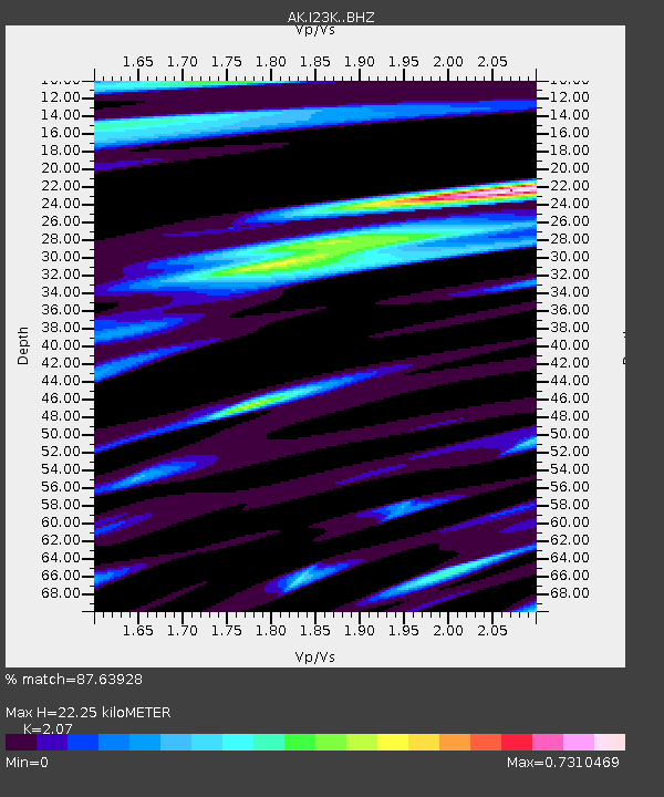
| Estimated Moho Depth: |
22.25 km |
| Estimated Crust Vp/Vs: |
2.07 |
| Assumed Crust Vp: |
6.566 km/s |
| Estimated Crust Vs: |
3.172 km/s |
| Estimated Crust Poisson's Ratio: |
0.35 |
|
| Radial Match: |
87.63928 % |
| Radial Bump: |
400 |
| Transverse Match: |
82.21259 % |
| Transverse Bump: |
400 |
| SOD ConfigId: |
33182351 |
| Insert Time: |
2023-12-11 21:50:45.216 +0000 |
| GWidth: |
2.5 |
| Max Bumps: |
400 |
| Tol: |
0.001 |
|

Signal To Noise
| Channel | StoN | STA | LTA |
| AK:I23K: :BHZ:20231127T21:58:39.179972Z | 3.2313547 | 4.3734144E-7 | 1.3534307E-7 |
| AK:I23K: :BHN:20231127T21:58:39.179972Z | 0.579826 | 1.2385814E-7 | 2.1361261E-7 |
| AK:I23K: :BHE:20231127T21:58:39.179972Z | 0.9404977 | 2.018793E-7 | 2.1465156E-7 |
| Arrivals |
| Ps | 3.7 SECOND |
| PpPs | 10 SECOND |
| PsPs/PpSs | 14 SECOND |


