You are here: Home > Network List > UU - University of Utah Regional Network Stations List
> Station WPUT Wasatch Plateau, UT,USA > Earthquake Result Viewer
WPUT Wasatch Plateau, UT,USA - Earthquake Result Viewer
| Earthquake location: |
Peru-Ecuador Border Region |
| Earthquake latitude/longitude: |
-2.2/-77.0 |
| Earthquake time(UTC): |
2019/02/22 (053) 10:17:22 GMT |
| Earthquake Depth: |
132 km |
| Earthquake Magnitude: |
7.5 mww |
| Earthquake Catalog/Contributor: |
NEIC PDE/us |
|
| Network: |
UU University of Utah Regional Network |
| Station: |
WPUT Wasatch Plateau, UT,USA |
| Lat/Lon: |
39.00 N/111.36 W |
| Elevation: |
2618 m |
|
| Distance: |
51.7 deg |
| Az: |
325.967 deg |
| Baz: |
134.134 deg |
| Ray Param: |
0.06676493 |
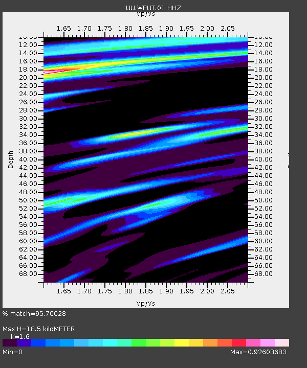
| Estimated Moho Depth: |
18.5 km |
| Estimated Crust Vp/Vs: |
1.60 |
| Assumed Crust Vp: |
6.207 km/s |
| Estimated Crust Vs: |
3.879 km/s |
| Estimated Crust Poisson's Ratio: |
0.18 |
|
| Radial Match: |
95.70028 % |
| Radial Bump: |
400 |
| Transverse Match: |
89.196045 % |
| Transverse Bump: |
400 |
| SOD ConfigId: |
3313551 |
| Insert Time: |
2019-03-08 10:29:27.694 +0000 |
| GWidth: |
2.5 |
| Max Bumps: |
400 |
| Tol: |
0.001 |
|

Signal To Noise
| Channel | StoN | STA | LTA |
| UU:WPUT:01:HHZ:20190222T10:25:45.719998Z | 40.091743 | 1.6059049E-7 | 4.005575E-9 |
| UU:WPUT:01:HHN:20190222T10:25:45.719998Z | 8.233862 | 3.9695433E-8 | 4.8209983E-9 |
| UU:WPUT:01:HHE:20190222T10:25:45.719998Z | 8.348042 | 4.7906543E-8 | 5.738656E-9 |
| Arrivals |
| Ps | 1.9 SECOND |
| PpPs | 7.3 SECOND |
| PsPs/PpSs | 9.2 SECOND |


