You are here: Home > Network List > AK - Alaska Regional Network Stations List
> Station WAT6 Susitna Watana 6, AK, USA > Earthquake Result Viewer
WAT6 Susitna Watana 6, AK, USA - Earthquake Result Viewer
| Earthquake location: |
Near N Coast Of New Guinea, P.N.G. |
| Earthquake latitude/longitude: |
-3.6/144.0 |
| Earthquake time(UTC): |
2023/11/27 (331) 21:46:41 GMT |
| Earthquake Depth: |
8.0 km |
| Earthquake Magnitude: |
6.5 Mww |
| Earthquake Catalog/Contributor: |
NEIC PDE/us |
|
| Network: |
AK Alaska Regional Network |
| Station: |
WAT6 Susitna Watana 6, AK, USA |
| Lat/Lon: |
62.58 N/147.74 W |
| Elevation: |
1681 m |
|
| Distance: |
83.3 deg |
| Az: |
25.648 deg |
| Baz: |
248.938 deg |
| Ray Param: |
0.046290744 |
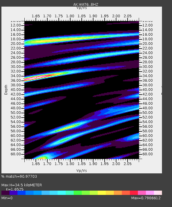
| Estimated Moho Depth: |
34.5 km |
| Estimated Crust Vp/Vs: |
1.65 |
| Assumed Crust Vp: |
6.566 km/s |
| Estimated Crust Vs: |
3.973 km/s |
| Estimated Crust Poisson's Ratio: |
0.21 |
|
| Radial Match: |
90.97703 % |
| Radial Bump: |
400 |
| Transverse Match: |
74.31293 % |
| Transverse Bump: |
400 |
| SOD ConfigId: |
33182351 |
| Insert Time: |
2023-12-11 21:51:46.054 +0000 |
| GWidth: |
2.5 |
| Max Bumps: |
400 |
| Tol: |
0.001 |
|

Signal To Noise
| Channel | StoN | STA | LTA |
| AK:WAT6: :BHZ:20231127T21:58:37.668009Z | 2.4056802 | 4.5679613E-7 | 1.8988233E-7 |
| AK:WAT6: :BHN:20231127T21:58:37.668009Z | 0.96177095 | 2.1524096E-7 | 2.2379649E-7 |
| AK:WAT6: :BHE:20231127T21:58:37.668009Z | 1.3658953 | 2.3978745E-7 | 1.7555331E-7 |
| Arrivals |
| Ps | 3.5 SECOND |
| PpPs | 14 SECOND |
| PsPs/PpSs | 17 SECOND |


