You are here: Home > Network List > AV - Alaska Volcano Observatory Stations List
> Station KARR Katmai Rainbow River, Alaska > Earthquake Result Viewer
KARR Katmai Rainbow River, Alaska - Earthquake Result Viewer
| Earthquake location: |
Near N Coast Of New Guinea, P.N.G. |
| Earthquake latitude/longitude: |
-3.6/144.0 |
| Earthquake time(UTC): |
2023/11/27 (331) 21:46:41 GMT |
| Earthquake Depth: |
8.0 km |
| Earthquake Magnitude: |
6.5 Mww |
| Earthquake Catalog/Contributor: |
NEIC PDE/us |
|
| Network: |
AV Alaska Volcano Observatory |
| Station: |
KARR Katmai Rainbow River, Alaska |
| Lat/Lon: |
58.50 N/154.71 W |
| Elevation: |
610 m |
|
| Distance: |
78.5 deg |
| Az: |
28.022 deg |
| Baz: |
243.254 deg |
| Ray Param: |
0.049607214 |
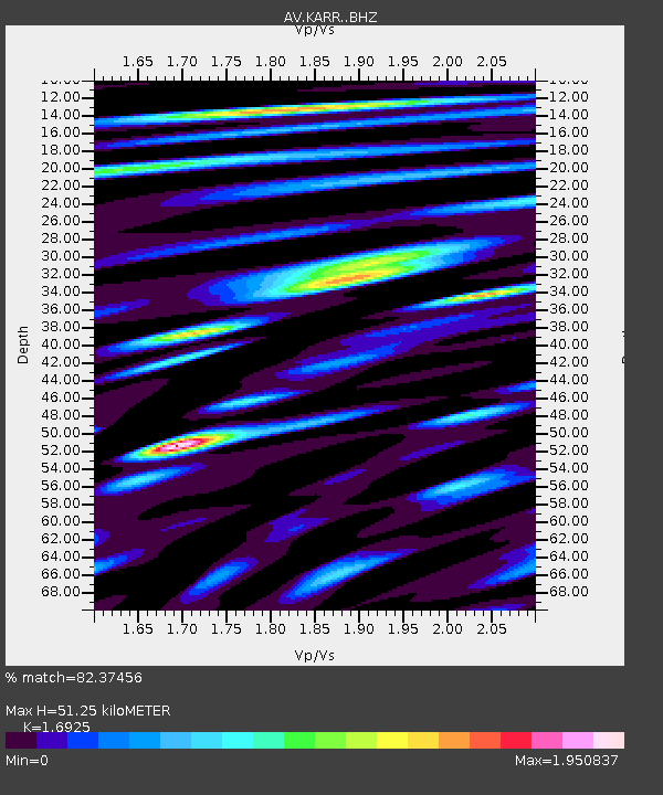
| Estimated Moho Depth: |
51.25 km |
| Estimated Crust Vp/Vs: |
1.69 |
| Assumed Crust Vp: |
6.438 km/s |
| Estimated Crust Vs: |
3.804 km/s |
| Estimated Crust Poisson's Ratio: |
0.23 |
|
| Radial Match: |
82.37456 % |
| Radial Bump: |
400 |
| Transverse Match: |
69.72643 % |
| Transverse Bump: |
400 |
| SOD ConfigId: |
33182351 |
| Insert Time: |
2023-12-11 21:53:06.916 +0000 |
| GWidth: |
2.5 |
| Max Bumps: |
400 |
| Tol: |
0.001 |
|
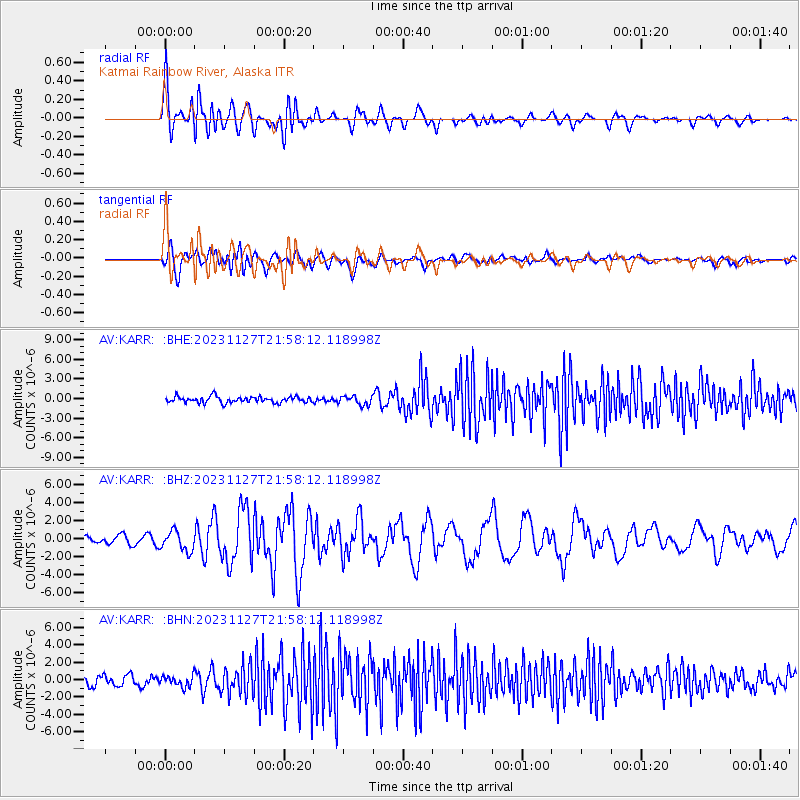
Signal To Noise
| Channel | StoN | STA | LTA |
| AV:KARR: :BHZ:20231127T21:58:12.118998Z | 2.8314488 | 1.1173996E-6 | 3.9463882E-7 |
| AV:KARR: :BHN:20231127T21:58:12.118998Z | 1.2560799 | 6.425096E-7 | 5.115197E-7 |
| AV:KARR: :BHE:20231127T21:58:12.118998Z | 1.4379622 | 6.829022E-7 | 4.7490974E-7 |
| Arrivals |
| Ps | 5.7 SECOND |
| PpPs | 21 SECOND |
| PsPs/PpSs | 26 SECOND |


