You are here: Home > Network List > IU - Global Seismograph Network (GSN - IRIS/USGS) Stations List
> Station ULN Ulaanbaatar, Mongolia > Earthquake Result Viewer
ULN Ulaanbaatar, Mongolia - Earthquake Result Viewer
| Earthquake location: |
Near N Coast Of New Guinea, P.N.G. |
| Earthquake latitude/longitude: |
-3.6/144.0 |
| Earthquake time(UTC): |
2023/11/27 (331) 21:46:41 GMT |
| Earthquake Depth: |
8.0 km |
| Earthquake Magnitude: |
6.5 Mww |
| Earthquake Catalog/Contributor: |
NEIC PDE/us |
|
| Network: |
IU Global Seismograph Network (GSN - IRIS/USGS) |
| Station: |
ULN Ulaanbaatar, Mongolia |
| Lat/Lon: |
47.87 N/107.05 E |
| Elevation: |
1610 m |
|
| Distance: |
60.6 deg |
| Az: |
332.286 deg |
| Baz: |
136.422 deg |
| Ray Param: |
0.06145094 |
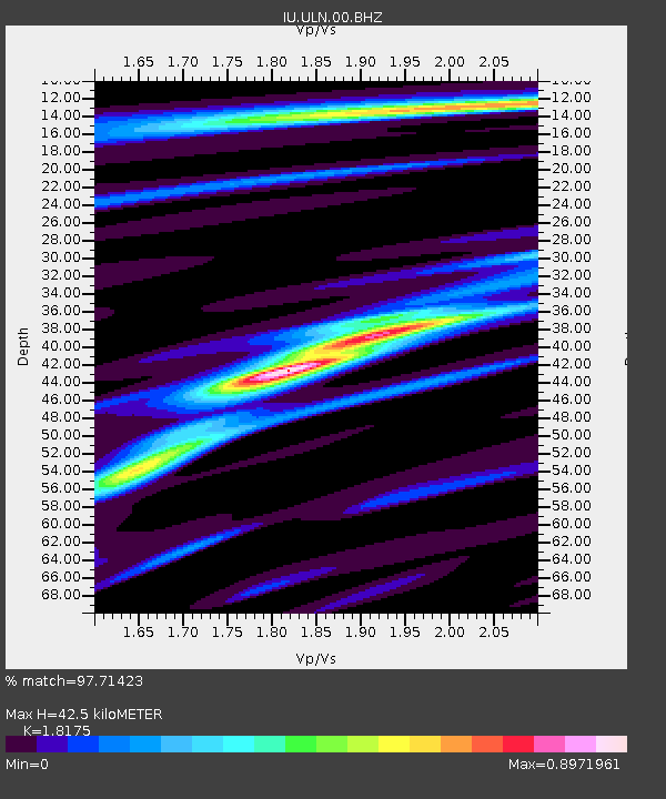
| Estimated Moho Depth: |
42.5 km |
| Estimated Crust Vp/Vs: |
1.82 |
| Assumed Crust Vp: |
6.642 km/s |
| Estimated Crust Vs: |
3.654 km/s |
| Estimated Crust Poisson's Ratio: |
0.28 |
|
| Radial Match: |
97.71423 % |
| Radial Bump: |
294 |
| Transverse Match: |
88.86463 % |
| Transverse Bump: |
400 |
| SOD ConfigId: |
33182351 |
| Insert Time: |
2023-12-11 21:58:00.846 +0000 |
| GWidth: |
2.5 |
| Max Bumps: |
400 |
| Tol: |
0.001 |
|
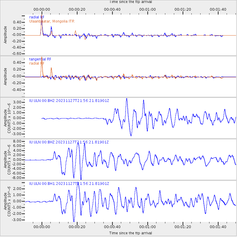
Signal To Noise
| Channel | StoN | STA | LTA |
| IU:ULN:00:BHZ:20231127T21:56:21.81901Z | 2.4415228 | 9.7571174E-8 | 3.9963247E-8 |
| IU:ULN:00:BH1:20231127T21:56:21.81901Z | 1.1856066 | 6.196443E-8 | 5.2263903E-8 |
| IU:ULN:00:BH2:20231127T21:56:21.81901Z | 0.9237326 | 4.464981E-8 | 4.8336293E-8 |
| Arrivals |
| Ps | 5.5 SECOND |
| PpPs | 17 SECOND |
| PsPs/PpSs | 23 SECOND |


