You are here: Home > Network List > PS - Pacific21 Stations List
> Station PSI Parapat, Indonesia > Earthquake Result Viewer
PSI Parapat, Indonesia - Earthquake Result Viewer
| Earthquake location: |
Near N Coast Of New Guinea, P.N.G. |
| Earthquake latitude/longitude: |
-3.6/144.0 |
| Earthquake time(UTC): |
2023/11/27 (331) 21:46:41 GMT |
| Earthquake Depth: |
8.0 km |
| Earthquake Magnitude: |
6.5 Mww |
| Earthquake Catalog/Contributor: |
NEIC PDE/us |
|
| Network: |
PS Pacific21 |
| Station: |
PSI Parapat, Indonesia |
| Lat/Lon: |
2.69 N/98.92 E |
| Elevation: |
987 m |
|
| Distance: |
45.5 deg |
| Az: |
277.263 deg |
| Baz: |
97.625 deg |
| Ray Param: |
0.07123427 |
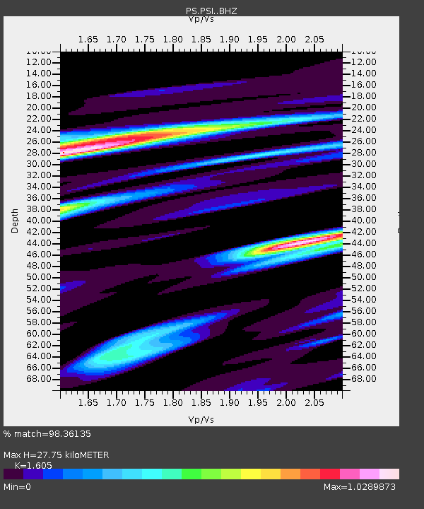
| Estimated Moho Depth: |
27.75 km |
| Estimated Crust Vp/Vs: |
1.61 |
| Assumed Crust Vp: |
6.468 km/s |
| Estimated Crust Vs: |
4.03 km/s |
| Estimated Crust Poisson's Ratio: |
0.18 |
|
| Radial Match: |
98.36135 % |
| Radial Bump: |
354 |
| Transverse Match: |
94.77432 % |
| Transverse Bump: |
400 |
| SOD ConfigId: |
33182351 |
| Insert Time: |
2023-12-11 21:59:40.102 +0000 |
| GWidth: |
2.5 |
| Max Bumps: |
400 |
| Tol: |
0.001 |
|
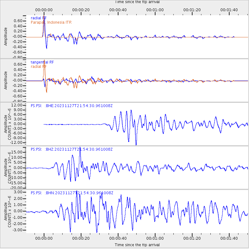
Signal To Noise
| Channel | StoN | STA | LTA |
| PS:PSI: :BHZ:20231127T21:54:30.961008Z | 6.0223713 | 3.8048464E-7 | 6.317854E-8 |
| PS:PSI: :BHN:20231127T21:54:30.961008Z | 2.8913534 | 1.2364033E-7 | 4.27621E-8 |
| PS:PSI: :BHE:20231127T21:54:30.961008Z | 4.723668 | 2.5725166E-7 | 5.446015E-8 |
| Arrivals |
| Ps | 2.8 SECOND |
| PpPs | 10 SECOND |
| PsPs/PpSs | 13 SECOND |


