You are here: Home > Network List > US - United States National Seismic Network Stations List
> Station MNTX Cornudas Mountains, Texas, USA > Earthquake Result Viewer
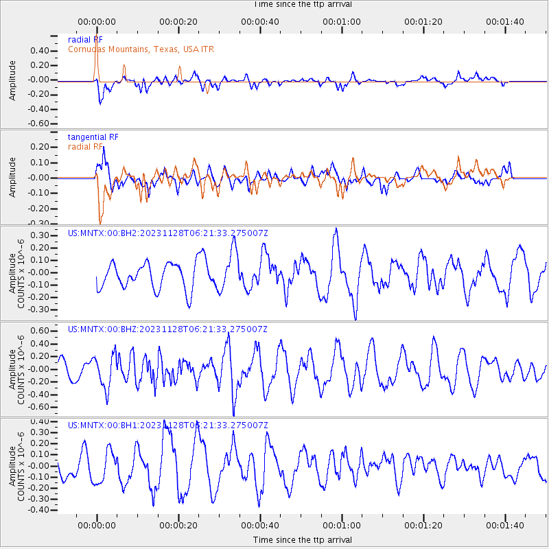
MNTX Cornudas Mountains, Texas, USA - Earthquake Result Viewer
*The percent match for this event was below the threshold and hence no stack was calculated.
| Earthquake location: |
Fox Islands, Aleutian Islands |
| Earthquake latitude/longitude: |
52.7/-167.1 |
| Earthquake time(UTC): |
2023/11/28 (332) 06:13:22 GMT |
| Earthquake Depth: |
26 km |
| Earthquake Magnitude: |
5.6 Mww |
| Earthquake Catalog/Contributor: |
NEIC PDE/us |
|
| Network: |
US United States National Seismic Network |
| Station: |
MNTX Cornudas Mountains, Texas, USA |
| Lat/Lon: |
31.70 N/105.38 W |
| Elevation: |
405 m |
|
| Distance: |
48.6 deg |
| Az: |
90.205 deg |
| Baz: |
314.492 deg |
| Ray Param: |
$rayparam |
*The percent match for this event was below the threshold and hence was not used in the summary stack. |
|
| Radial Match: |
36.596794 % |
| Radial Bump: |
400 |
| Transverse Match: |
61.625465 % |
| Transverse Bump: |
400 |
| SOD ConfigId: |
33182351 |
| Insert Time: |
2023-12-12 06:37:00.047 +0000 |
| GWidth: |
2.5 |
| Max Bumps: |
400 |
| Tol: |
0.001 |
|
Signal To Noise
| Channel | StoN | STA | LTA |
| US:MNTX:00:BHZ:20231128T06:21:33.275007Z | 2.2707324 | 2.643406E-7 | 1.1641203E-7 |
| US:MNTX:00:BH1:20231128T06:21:33.275007Z | 1.5202795 | 1.4106388E-7 | 9.278811E-8 |
| US:MNTX:00:BH2:20231128T06:21:33.275007Z | 1.6319066 | 1.6672877E-7 | 1.0216808E-7 |
| Arrivals |
| Ps | |
| PpPs | |
| PsPs/PpSs | |


