You are here: Home > Network List > GS - US Geological Survey Networks Stations List
> Station OK051 E0350 and S34600 roads, Ralston OK > Earthquake Result Viewer
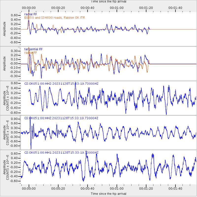
OK051 E0350 and S34600 roads, Ralston OK - Earthquake Result Viewer
*The percent match for this event was below the threshold and hence no stack was calculated.
| Earthquake location: |
Windward Islands |
| Earthquake latitude/longitude: |
12.6/-59.8 |
| Earthquake time(UTC): |
2023/11/28 (332) 15:26:12 GMT |
| Earthquake Depth: |
39 km |
| Earthquake Magnitude: |
5.1 Mww |
| Earthquake Catalog/Contributor: |
NEIC PDE/us |
|
| Network: |
GS US Geological Survey Networks |
| Station: |
OK051 E0350 and S34600 roads, Ralston OK |
| Lat/Lon: |
36.50 N/96.84 W |
| Elevation: |
263 m |
|
| Distance: |
40.8 deg |
| Az: |
312.072 deg |
| Baz: |
115.942 deg |
| Ray Param: |
$rayparam |
*The percent match for this event was below the threshold and hence was not used in the summary stack. |
|
| Radial Match: |
52.09291 % |
| Radial Bump: |
400 |
| Transverse Match: |
60.74894 % |
| Transverse Bump: |
400 |
| SOD ConfigId: |
33182351 |
| Insert Time: |
2023-12-12 15:38:24.060 +0000 |
| GWidth: |
2.5 |
| Max Bumps: |
400 |
| Tol: |
0.001 |
|
Signal To Noise
| Channel | StoN | STA | LTA |
| GS:OK051:00:HHZ:20231128T15:33:19.730004Z | 1.8684012 | 3.8393304E-7 | 2.0548748E-7 |
| GS:OK051:00:HH1:20231128T15:33:19.730004Z | 0.53147036 | 1.2971576E-7 | 2.4406958E-7 |
| GS:OK051:00:HH2:20231128T15:33:19.730004Z | 1.108931 | 2.7305921E-7 | 2.4623645E-7 |
| Arrivals |
| Ps | |
| PpPs | |
| PsPs/PpSs | |


