You are here: Home > Network List > UW - Pacific Northwest Regional Seismic Network Stations List
> Station PASS Maple Falls, WA, USA > Earthquake Result Viewer
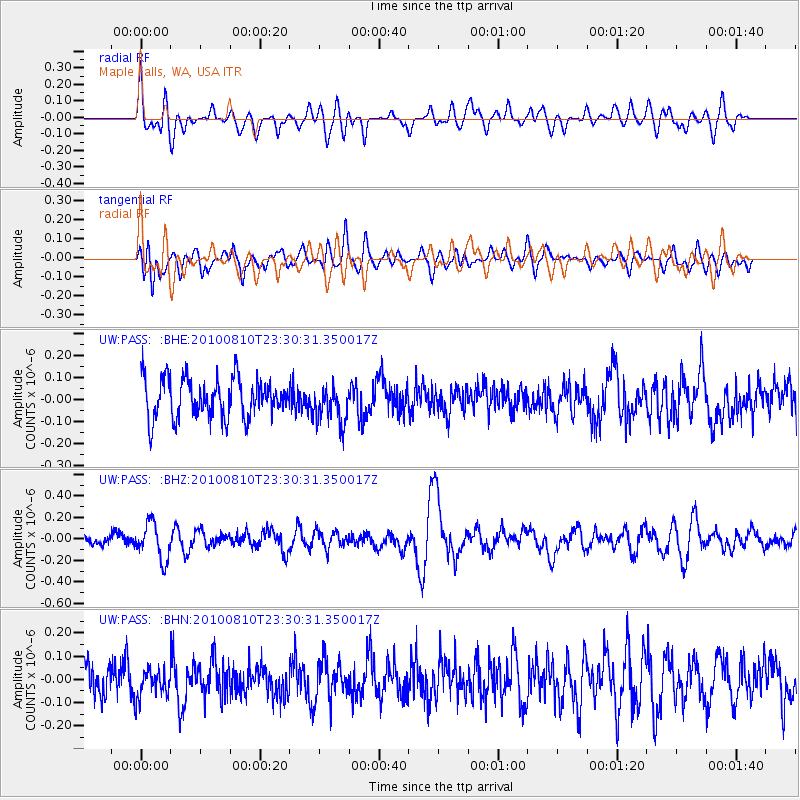
PASS Maple Falls, WA, USA - Earthquake Result Viewer
*The percent match for this event was below the threshold and hence no stack was calculated.
| Earthquake location: |
Vanuatu Islands |
| Earthquake latitude/longitude: |
-14.5/167.3 |
| Earthquake time(UTC): |
2010/08/10 (222) 23:18:31 GMT |
| Earthquake Depth: |
192 km |
| Earthquake Magnitude: |
5.9 MW, 5.4 MB, 5.9 MW |
| Earthquake Catalog/Contributor: |
WHDF/NEIC |
|
| Network: |
UW Pacific Northwest Regional Seismic Network |
| Station: |
PASS Maple Falls, WA, USA |
| Lat/Lon: |
49.00 N/122.09 W |
| Elevation: |
174 m |
|
| Distance: |
88.5 deg |
| Az: |
38.41 deg |
| Baz: |
246.043 deg |
| Ray Param: |
$rayparam |
*The percent match for this event was below the threshold and hence was not used in the summary stack. |
|
| Radial Match: |
62.802547 % |
| Radial Bump: |
400 |
| Transverse Match: |
49.138256 % |
| Transverse Bump: |
400 |
| SOD ConfigId: |
319893 |
| Insert Time: |
2011-01-05 19:55:04.185 +0000 |
| GWidth: |
2.5 |
| Max Bumps: |
400 |
| Tol: |
0.001 |
|
Signal To Noise
| Channel | StoN | STA | LTA |
| UW:PASS: :BHZ:20100810T23:30:31.350017Z | 3.0051699 | 1.7034226E-7 | 5.6683074E-8 |
| UW:PASS: :BHN:20100810T23:30:31.350017Z | 0.8635167 | 6.044707E-8 | 7.000105E-8 |
| UW:PASS: :BHE:20100810T23:30:31.350017Z | 0.96552455 | 8.618654E-8 | 8.9263956E-8 |
| Arrivals |
| Ps | |
| PpPs | |
| PsPs/PpSs | |


