You are here: Home > Network List > AZ - ANZA Regional Network Stations List
> Station BZN AZ.BZN > Earthquake Result Viewer
BZN AZ.BZN - Earthquake Result Viewer
| Earthquake location: |
Kuril Islands |
| Earthquake latitude/longitude: |
46.6/153.3 |
| Earthquake time(UTC): |
2006/11/15 (319) 11:14:13 GMT |
| Earthquake Depth: |
10 km |
| Earthquake Magnitude: |
6.5 MB, 7.8 MS, 8.3 MW, 7.9 MW |
| Earthquake Catalog/Contributor: |
WHDF/NEIC |
|
| Network: |
AZ ANZA Regional Network |
| Station: |
BZN AZ.BZN |
| Lat/Lon: |
33.49 N/116.67 W |
| Elevation: |
1301 m |
|
| Distance: |
66.6 deg |
| Az: |
65.577 deg |
| Baz: |
311.289 deg |
| Ray Param: |
0.057505738 |
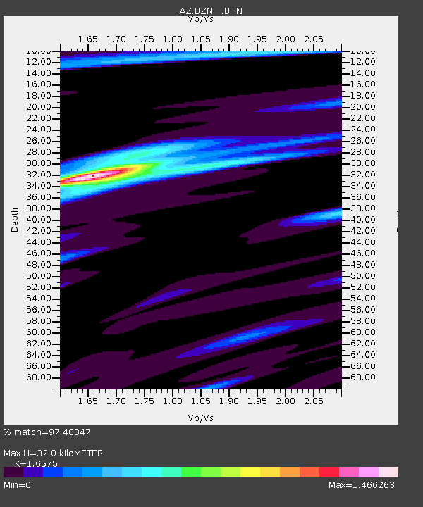
| Estimated Moho Depth: |
32.0 km |
| Estimated Crust Vp/Vs: |
1.66 |
| Assumed Crust Vp: |
6.264 km/s |
| Estimated Crust Vs: |
3.779 km/s |
| Estimated Crust Poisson's Ratio: |
0.21 |
|
| Radial Match: |
97.48847 % |
| Radial Bump: |
323 |
| Transverse Match: |
95.049515 % |
| Transverse Bump: |
400 |
| SOD ConfigId: |
2564 |
| Insert Time: |
2010-02-26 18:44:54.662 +0000 |
| GWidth: |
2.5 |
| Max Bumps: |
400 |
| Tol: |
0.001 |
|

Signal To Noise
| Channel | StoN | STA | LTA |
| AZ:BZN: :BHN:20061115T11:24:32.793022Z | 2.435753 | 6.2152253E-7 | 2.5516647E-7 |
| AZ:BZN: :BHE:20061115T11:24:32.793022Z | 2.228919 | 5.626919E-7 | 2.524506E-7 |
| AZ:BZN: :BHZ:20061115T11:24:32.793022Z | 6.4772663 | 1.6610443E-6 | 2.5644218E-7 |
| Arrivals |
| Ps | 3.5 SECOND |
| PpPs | 13 SECOND |
| PsPs/PpSs | 17 SECOND |


