You are here: Home > Network List > GM - US Geological Survey Networks Stations List
> Station IWM01 Jericho 2M Well Monitoring Station > Earthquake Result Viewer
IWM01 Jericho 2M Well Monitoring Station - Earthquake Result Viewer

| Earthquake location: |
Northern Chile |
| Earthquake latitude/longitude: |
-19.2/-69.1 |
| Earthquake time(UTC): |
2023/12/02 (336) 07:55:40 GMT |
| Earthquake Depth: |
106 km |
| Earthquake Magnitude: |
5.8 Mww |
| Earthquake Catalog/Contributor: |
NEIC PDE/us |
|
| Network: |
GM US Geological Survey Networks |
| Station: |
IWM01 Jericho 2M Well Monitoring Station |
| Lat/Lon: |
36.73 N/96.53 W |
| Elevation: |
328 m |
|
| Distance: |
61.4 deg |
| Az: |
335.053 deg |
| Baz: |
150.256 deg |
| Ray Param: |
0.060629196 |
| Estimated Moho Depth: |
27.25 km |
| Estimated Crust Vp/Vs: |
1.64 |
| Assumed Crust Vp: |
6.483 km/s |
| Estimated Crust Vs: |
3.947 km/s |
| Estimated Crust Poisson's Ratio: |
0.21 |
|
| Radial Match: |
83.57281 % |
| Radial Bump: |
400 |
| Transverse Match: |
51.39437 % |
| Transverse Bump: |
400 |
| SOD ConfigId: |
33232451 |
| Insert Time: |
2023-12-16 08:07:54.251 +0000 |
| GWidth: |
2.5 |
| Max Bumps: |
400 |
| Tol: |
0.001 |
|
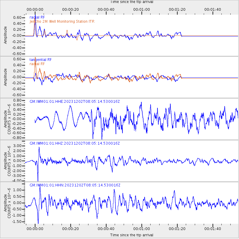
Signal To Noise
| Channel | StoN | STA | LTA |
| GM:IWM01:01:HHZ:20231202T08:05:14.530016Z | 3.9293332 | 1.1852719E-6 | 3.0164708E-7 |
| GM:IWM01:01:HHN:20231202T08:05:14.530016Z | 2.2260354 | 6.344823E-7 | 2.8502797E-7 |
| GM:IWM01:01:HHE:20231202T08:05:14.530016Z | 1.2145292 | 2.9202903E-7 | 2.404463E-7 |
| Arrivals |
| Ps | 2.8 SECOND |
| PpPs | 11 SECOND |
| PsPs/PpSs | 13 SECOND |


