You are here: Home > Network List > JP - Japan Meteorological Agency Seismic Network Stations List
> Station ASAJ Kamikawa Asahi > Earthquake Result Viewer
ASAJ Kamikawa Asahi - Earthquake Result Viewer
| Earthquake location: |
Vanuatu Islands |
| Earthquake latitude/longitude: |
-17.4/167.8 |
| Earthquake time(UTC): |
2010/08/11 (223) 03:35:19 GMT |
| Earthquake Depth: |
35 km |
| Earthquake Magnitude: |
5.6 MB, 5.7 MS, 5.8 MW |
| Earthquake Catalog/Contributor: |
WHDF/NEIC |
|
| Network: |
JP Japan Meteorological Agency Seismic Network |
| Station: |
ASAJ Kamikawa Asahi |
| Lat/Lon: |
44.12 N/142.59 E |
| Elevation: |
220 m |
|
| Distance: |
65.4 deg |
| Az: |
340.277 deg |
| Baz: |
153.425 deg |
| Ray Param: |
0.058222935 |
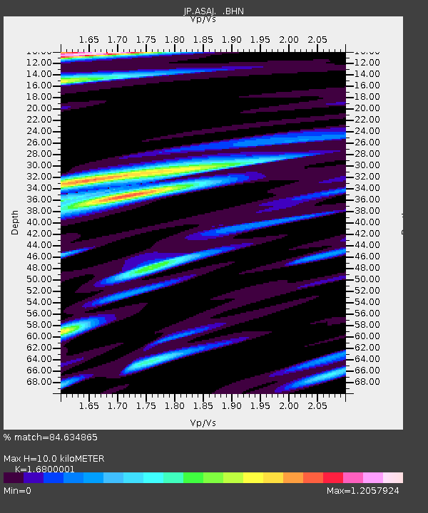
| Estimated Moho Depth: |
10.0 km |
| Estimated Crust Vp/Vs: |
1.68 |
| Assumed Crust Vp: |
6.183 km/s |
| Estimated Crust Vs: |
3.68 km/s |
| Estimated Crust Poisson's Ratio: |
0.23 |
|
| Radial Match: |
84.634865 % |
| Radial Bump: |
400 |
| Transverse Match: |
48.930737 % |
| Transverse Bump: |
400 |
| SOD ConfigId: |
319893 |
| Insert Time: |
2011-01-05 20:03:35.724 +0000 |
| GWidth: |
2.5 |
| Max Bumps: |
400 |
| Tol: |
0.001 |
|

Signal To Noise
| Channel | StoN | STA | LTA |
| JP:ASAJ: :BHZ:20100811T03:45:27.600012Z | 7.8423553 | 7.646548E-7 | 9.750321E-8 |
| JP:ASAJ: :BHN:20100811T03:45:27.600012Z | 2.7336152 | 2.69572E-7 | 9.861374E-8 |
| JP:ASAJ: :BHE:20100811T03:45:27.600012Z | 1.3442969 | 3.0074247E-7 | 2.2371731E-7 |
| Arrivals |
| Ps | 1.1 SECOND |
| PpPs | 4.2 SECOND |
| PsPs/PpSs | 5.3 SECOND |


