You are here: Home > Network List > TA - USArray Transportable Network (new EarthScope stations) Stations List
> Station R11A Troy Canyon, Currant, NV, USA > Earthquake Result Viewer
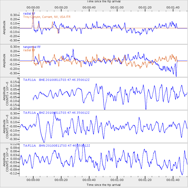
R11A Troy Canyon, Currant, NV, USA - Earthquake Result Viewer
*The percent match for this event was below the threshold and hence no stack was calculated.
| Earthquake location: |
Vanuatu Islands |
| Earthquake latitude/longitude: |
-17.4/167.8 |
| Earthquake time(UTC): |
2010/08/11 (223) 03:35:19 GMT |
| Earthquake Depth: |
35 km |
| Earthquake Magnitude: |
5.6 MB, 5.7 MS, 5.8 MW |
| Earthquake Catalog/Contributor: |
WHDF/NEIC |
|
| Network: |
TA USArray Transportable Network (new EarthScope stations) |
| Station: |
R11A Troy Canyon, Currant, NV, USA |
| Lat/Lon: |
38.35 N/115.59 W |
| Elevation: |
1756 m |
|
| Distance: |
90.6 deg |
| Az: |
49.898 deg |
| Baz: |
248.256 deg |
| Ray Param: |
$rayparam |
*The percent match for this event was below the threshold and hence was not used in the summary stack. |
|
| Radial Match: |
71.05585 % |
| Radial Bump: |
400 |
| Transverse Match: |
56.25742 % |
| Transverse Bump: |
400 |
| SOD ConfigId: |
319893 |
| Insert Time: |
2011-01-05 20:04:54.824 +0000 |
| GWidth: |
2.5 |
| Max Bumps: |
400 |
| Tol: |
0.001 |
|
Signal To Noise
| Channel | StoN | STA | LTA |
| TA:R11A: :BHZ:20100811T03:47:46.350012Z | 2.5619485 | 1.5494165E-7 | 6.0478044E-8 |
| TA:R11A: :BHN:20100811T03:47:46.350012Z | 1.6709871 | 4.1042146E-8 | 2.4561617E-8 |
| TA:R11A: :BHE:20100811T03:47:46.350012Z | 1.923545 | 5.8790103E-8 | 3.0563413E-8 |
| Arrivals |
| Ps | |
| PpPs | |
| PsPs/PpSs | |


