You are here: Home > Network List > TX - Texas Seismological Network Stations List
> Station WTFS Witchita Falls > Earthquake Result Viewer
WTFS Witchita Falls - Earthquake Result Viewer
| Earthquake location: |
Northern Chile |
| Earthquake latitude/longitude: |
-19.2/-69.1 |
| Earthquake time(UTC): |
2023/12/02 (336) 07:55:40 GMT |
| Earthquake Depth: |
106 km |
| Earthquake Magnitude: |
5.8 Mww |
| Earthquake Catalog/Contributor: |
NEIC PDE/us |
|
| Network: |
TX Texas Seismological Network |
| Station: |
WTFS Witchita Falls |
| Lat/Lon: |
33.77 N/98.46 W |
| Elevation: |
277 m |
|
| Distance: |
59.7 deg |
| Az: |
331.744 deg |
| Baz: |
147.516 deg |
| Ray Param: |
0.061730523 |
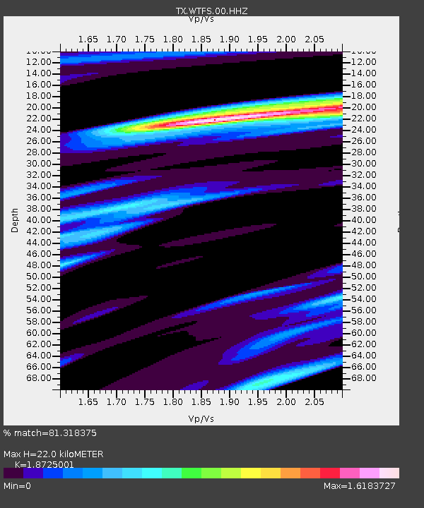
| Estimated Moho Depth: |
22.0 km |
| Estimated Crust Vp/Vs: |
1.87 |
| Assumed Crust Vp: |
6.426 km/s |
| Estimated Crust Vs: |
3.432 km/s |
| Estimated Crust Poisson's Ratio: |
0.30 |
|
| Radial Match: |
81.318375 % |
| Radial Bump: |
389 |
| Transverse Match: |
61.1029 % |
| Transverse Bump: |
364 |
| SOD ConfigId: |
33232451 |
| Insert Time: |
2023-12-16 08:23:17.569 +0000 |
| GWidth: |
2.5 |
| Max Bumps: |
400 |
| Tol: |
0.001 |
|

Signal To Noise
| Channel | StoN | STA | LTA |
| TX:WTFS:00:HHZ:20231202T08:05:02.924974Z | 7.0339575 | 1.5179669E-6 | 2.1580551E-7 |
| TX:WTFS:00:HH1:20231202T08:05:02.924974Z | 1.4770646 | 3.1318115E-7 | 2.1202942E-7 |
| TX:WTFS:00:HH2:20231202T08:05:02.924974Z | 3.4064248 | 6.757964E-7 | 1.9838876E-7 |
| Arrivals |
| Ps | 3.1 SECOND |
| PpPs | 9.4 SECOND |
| PsPs/PpSs | 13 SECOND |


