You are here: Home > Network List > 1E - GSC-BCOGC Induced Seismicity Study Stations List
> Station MONT4 Z > Earthquake Result Viewer
MONT4 Z - Earthquake Result Viewer
| Earthquake location: |
Mindanao, Philippines |
| Earthquake latitude/longitude: |
8.5/126.4 |
| Earthquake time(UTC): |
2023/12/02 (336) 14:37:03 GMT |
| Earthquake Depth: |
33 km |
| Earthquake Magnitude: |
7.6 mww |
| Earthquake Catalog/Contributor: |
NEIC PDE/us |
|
| Network: |
1E GSC-BCOGC Induced Seismicity Study |
| Station: |
MONT4 Z |
| Lat/Lon: |
57.32 N/122.71 W |
| Elevation: |
1110 m |
|
| Distance: |
93.9 deg |
| Az: |
30.542 deg |
| Baz: |
292.113 deg |
| Ray Param: |
0.041166022 |
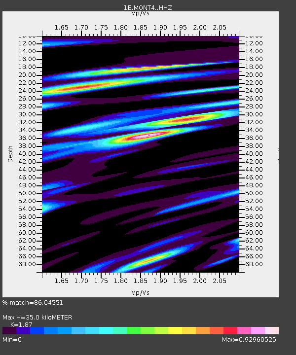
| Estimated Moho Depth: |
35.0 km |
| Estimated Crust Vp/Vs: |
1.87 |
| Assumed Crust Vp: |
6.232 km/s |
| Estimated Crust Vs: |
3.332 km/s |
| Estimated Crust Poisson's Ratio: |
0.30 |
|
| Radial Match: |
86.04551 % |
| Radial Bump: |
400 |
| Transverse Match: |
56.688297 % |
| Transverse Bump: |
400 |
| SOD ConfigId: |
33232451 |
| Insert Time: |
2023-12-16 14:38:08.729 +0000 |
| GWidth: |
2.5 |
| Max Bumps: |
400 |
| Tol: |
0.001 |
|

Signal To Noise
| Channel | StoN | STA | LTA |
| 1E:MONT4: :HHZ:20231202T14:49:46.59002Z | 3.8768725 | 4.5032516E-6 | 1.1615682E-6 |
| 1E:MONT4: :HHN:20231202T14:49:46.59002Z | 1.7746108 | 1.328403E-6 | 7.485602E-7 |
| 1E:MONT4: :HHE:20231202T14:49:46.59002Z | 1.9219792 | 1.9081122E-6 | 9.92785E-7 |
| Arrivals |
| Ps | 5.0 SECOND |
| PpPs | 16 SECOND |
| PsPs/PpSs | 21 SECOND |


