You are here: Home > Network List > 1E - GSC-BCOGC Induced Seismicity Study Stations List
> Station MONT7 Z > Earthquake Result Viewer
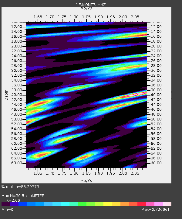
MONT7 Z - Earthquake Result Viewer
| Earthquake location: |
Mindanao, Philippines |
| Earthquake latitude/longitude: |
8.5/126.4 |
| Earthquake time(UTC): |
2023/12/02 (336) 14:37:03 GMT |
| Earthquake Depth: |
33 km |
| Earthquake Magnitude: |
7.6 mww |
| Earthquake Catalog/Contributor: |
NEIC PDE/us |
|
| Network: |
1E GSC-BCOGC Induced Seismicity Study |
| Station: |
MONT7 Z |
| Lat/Lon: |
56.31 N/122.03 W |
| Elevation: |
797 m |
|
| Distance: |
94.6 deg |
| Az: |
31.34 deg |
| Baz: |
292.617 deg |
| Ray Param: |
0.040996652 |
| Estimated Moho Depth: |
39.5 km |
| Estimated Crust Vp/Vs: |
2.06 |
| Assumed Crust Vp: |
6.232 km/s |
| Estimated Crust Vs: |
3.025 km/s |
| Estimated Crust Poisson's Ratio: |
0.35 |
|
| Radial Match: |
83.20773 % |
| Radial Bump: |
400 |
| Transverse Match: |
62.757103 % |
| Transverse Bump: |
400 |
| SOD ConfigId: |
33232451 |
| Insert Time: |
2023-12-16 14:38:12.587 +0000 |
| GWidth: |
2.5 |
| Max Bumps: |
400 |
| Tol: |
0.001 |
|

Signal To Noise
| Channel | StoN | STA | LTA |
| 1E:MONT7: :HHZ:20231202T14:49:49.910027Z | 4.959367 | 3.6000984E-6 | 7.2591894E-7 |
| 1E:MONT7: :HHN:20231202T14:49:49.910027Z | 0.7002968 | 6.025895E-7 | 8.6047726E-7 |
| 1E:MONT7: :HHE:20231202T14:49:49.910027Z | 0.61956304 | 5.785179E-7 | 9.3375155E-7 |
| Arrivals |
| Ps | 6.8 SECOND |
| PpPs | 19 SECOND |
| PsPs/PpSs | 26 SECOND |


