You are here: Home > Network List > 1E - GSC-BCOGC Induced Seismicity Study Stations List
> Station MONTA Z > Earthquake Result Viewer
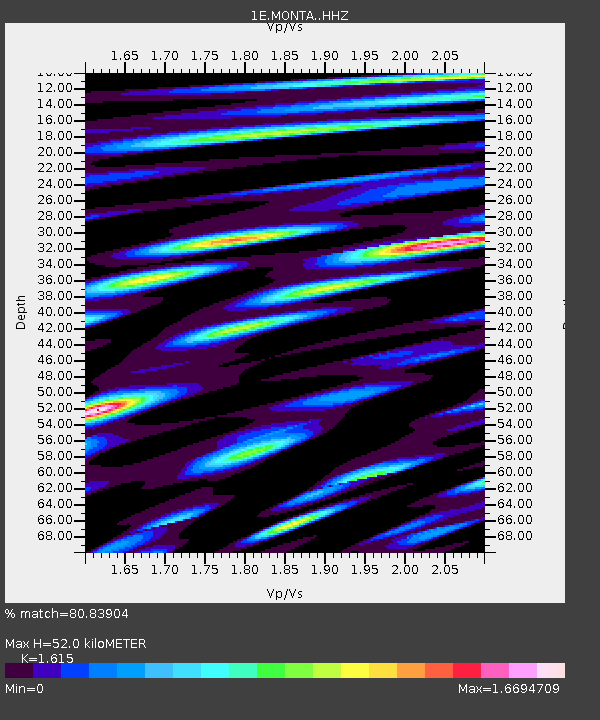
MONTA Z - Earthquake Result Viewer
| Earthquake location: |
Mindanao, Philippines |
| Earthquake latitude/longitude: |
8.5/126.4 |
| Earthquake time(UTC): |
2023/12/02 (336) 14:37:03 GMT |
| Earthquake Depth: |
33 km |
| Earthquake Magnitude: |
7.6 mww |
| Earthquake Catalog/Contributor: |
NEIC PDE/us |
|
| Network: |
1E GSC-BCOGC Induced Seismicity Study |
| Station: |
MONTA Z |
| Lat/Lon: |
56.10 N/121.07 W |
| Elevation: |
651 m |
|
| Distance: |
95.2 deg |
| Az: |
31.318 deg |
| Baz: |
293.416 deg |
| Ray Param: |
0.040852576 |
| Estimated Moho Depth: |
52.0 km |
| Estimated Crust Vp/Vs: |
1.62 |
| Assumed Crust Vp: |
6.291 km/s |
| Estimated Crust Vs: |
3.895 km/s |
| Estimated Crust Poisson's Ratio: |
0.19 |
|
| Radial Match: |
80.83904 % |
| Radial Bump: |
400 |
| Transverse Match: |
74.52654 % |
| Transverse Bump: |
400 |
| SOD ConfigId: |
33232451 |
| Insert Time: |
2023-12-16 14:38:15.735 +0000 |
| GWidth: |
2.5 |
| Max Bumps: |
400 |
| Tol: |
0.001 |
|

Signal To Noise
| Channel | StoN | STA | LTA |
| 1E:MONTA: :HHZ:20231202T14:49:52.510002Z | 4.485185 | 4.7399117E-6 | 1.0567928E-6 |
| 1E:MONTA: :HHN:20231202T14:49:52.510002Z | 1.0721221 | 7.5235437E-7 | 7.0174315E-7 |
| 1E:MONTA: :HHE:20231202T14:49:52.510002Z | 1.2503358 | 1.1650051E-6 | 9.3175373E-7 |
| Arrivals |
| Ps | 5.2 SECOND |
| PpPs | 21 SECOND |
| PsPs/PpSs | 26 SECOND |


