You are here: Home > Network List > AK - Alaska Regional Network Stations List
> Station P17K Kvichak River, AK, USA > Earthquake Result Viewer
P17K Kvichak River, AK, USA - Earthquake Result Viewer
| Earthquake location: |
Mindanao, Philippines |
| Earthquake latitude/longitude: |
8.5/126.4 |
| Earthquake time(UTC): |
2023/12/02 (336) 14:37:03 GMT |
| Earthquake Depth: |
33 km |
| Earthquake Magnitude: |
7.6 mww |
| Earthquake Catalog/Contributor: |
NEIC PDE/us |
|
| Network: |
AK Alaska Regional Network |
| Station: |
P17K Kvichak River, AK, USA |
| Lat/Lon: |
59.20 N/156.44 W |
| Elevation: |
91 m |
|
| Distance: |
76.1 deg |
| Az: |
31.116 deg |
| Baz: |
263.295 deg |
| Ray Param: |
0.051159725 |
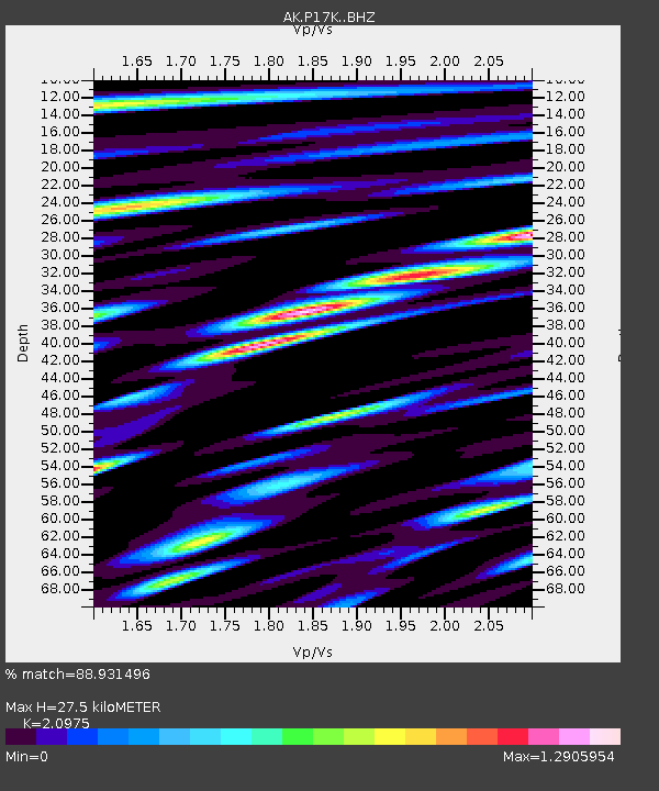
| Estimated Moho Depth: |
27.5 km |
| Estimated Crust Vp/Vs: |
2.10 |
| Assumed Crust Vp: |
6.276 km/s |
| Estimated Crust Vs: |
2.992 km/s |
| Estimated Crust Poisson's Ratio: |
0.35 |
|
| Radial Match: |
88.931496 % |
| Radial Bump: |
400 |
| Transverse Match: |
90.5242 % |
| Transverse Bump: |
400 |
| SOD ConfigId: |
33232451 |
| Insert Time: |
2023-12-16 14:41:50.822 +0000 |
| GWidth: |
2.5 |
| Max Bumps: |
400 |
| Tol: |
0.001 |
|

Signal To Noise
| Channel | StoN | STA | LTA |
| AK:P17K: :BHZ:20231202T14:48:17.460015Z | 24.994297 | 1.0245573E-5 | 4.0991642E-7 |
| AK:P17K: :BHN:20231202T14:48:17.460015Z | 1.5231661 | 1.8401231E-6 | 1.2080909E-6 |
| AK:P17K: :BHE:20231202T14:48:17.460015Z | 3.7932734 | 2.810221E-6 | 7.408433E-7 |
| Arrivals |
| Ps | 4.9 SECOND |
| PpPs | 13 SECOND |
| PsPs/PpSs | 18 SECOND |


