You are here: Home > Network List > AV - Alaska Volcano Observatory Stations List
> Station AMKA Regional Station, Amchitka Island, Alaska > Earthquake Result Viewer
AMKA Regional Station, Amchitka Island, Alaska - Earthquake Result Viewer
| Earthquake location: |
Mindanao, Philippines |
| Earthquake latitude/longitude: |
8.5/126.4 |
| Earthquake time(UTC): |
2023/12/02 (336) 14:37:03 GMT |
| Earthquake Depth: |
33 km |
| Earthquake Magnitude: |
7.6 mww |
| Earthquake Catalog/Contributor: |
NEIC PDE/us |
|
| Network: |
AV Alaska Volcano Observatory |
| Station: |
AMKA Regional Station, Amchitka Island, Alaska |
| Lat/Lon: |
51.38 N/179.30 E |
| Elevation: |
116 m |
|
| Distance: |
60.7 deg |
| Az: |
34.942 deg |
| Baz: |
244.675 deg |
| Ray Param: |
0.061304443 |
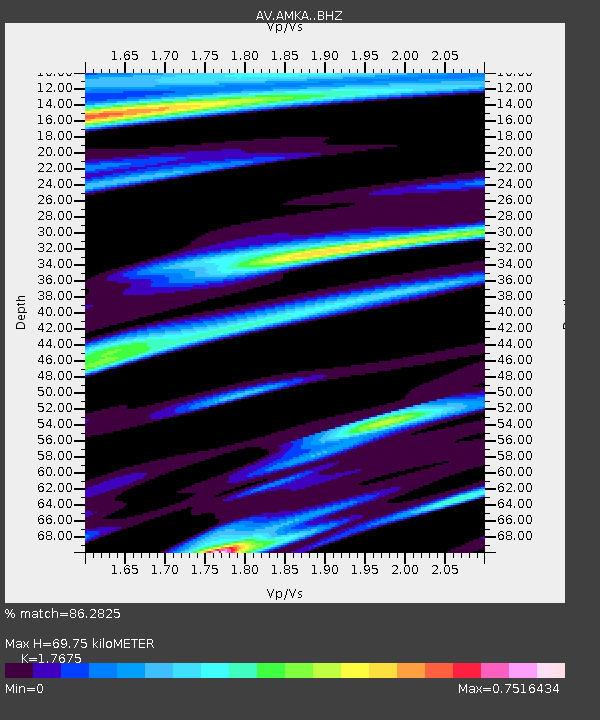
| Estimated Moho Depth: |
69.75 km |
| Estimated Crust Vp/Vs: |
1.77 |
| Assumed Crust Vp: |
6.183 km/s |
| Estimated Crust Vs: |
3.498 km/s |
| Estimated Crust Poisson's Ratio: |
0.26 |
|
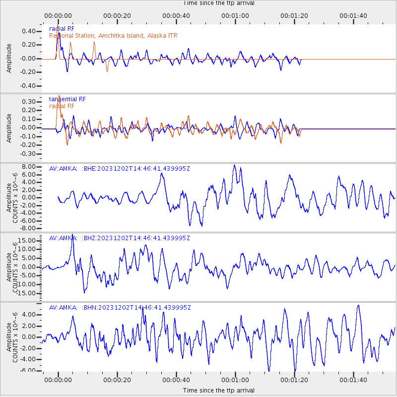
| Radial Match: |
86.2825 % |
| Radial Bump: |
363 |
| Transverse Match: |
76.03812 % |
| Transverse Bump: |
400 |
| SOD ConfigId: |
33232451 |
| Insert Time: |
2023-12-16 14:44:02.374 +0000 |
| GWidth: |
2.5 |
| Max Bumps: |
400 |
| Tol: |
0.001 |
|
Signal To Noise
| Channel | StoN | STA | LTA |
| AV:AMKA: :BHZ:20231202T14:46:41.439995Z | 5.3642454 | 5.0874683E-6 | 9.4840334E-7 |
| AV:AMKA: :BHN:20231202T14:46:41.439995Z | 1.1839021 | 1.0945074E-6 | 9.244915E-7 |
| AV:AMKA: :BHE:20231202T14:46:41.439995Z | 2.1981938 | 2.0246496E-6 | 9.210515E-7 |
| Arrivals |
| Ps | 9.0 SECOND |
| PpPs | 30 SECOND |
| PsPs/PpSs | 39 SECOND |


