You are here: Home > Network List > AZ - ANZA Regional Network Stations List
> Station SOL AZ.SOL > Earthquake Result Viewer
SOL AZ.SOL - Earthquake Result Viewer
| Earthquake location: |
Ecuador |
| Earthquake latitude/longitude: |
-1.3/-77.3 |
| Earthquake time(UTC): |
2010/08/12 (224) 11:54:15 GMT |
| Earthquake Depth: |
207 km |
| Earthquake Magnitude: |
6.4 MB, 7.1 MW, 7.1 MW |
| Earthquake Catalog/Contributor: |
WHDF/NEIC |
|
| Network: |
AZ ANZA Regional Network |
| Station: |
SOL AZ.SOL |
| Lat/Lon: |
32.84 N/117.25 W |
| Elevation: |
245 m |
|
| Distance: |
50.7 deg |
| Az: |
315.697 deg |
| Baz: |
123.954 deg |
| Ray Param: |
0.06714159 |
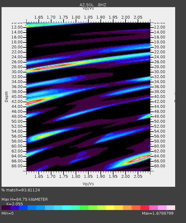
| Estimated Moho Depth: |
64.75 km |
| Estimated Crust Vp/Vs: |
2.06 |
| Assumed Crust Vp: |
6.264 km/s |
| Estimated Crust Vs: |
3.048 km/s |
| Estimated Crust Poisson's Ratio: |
0.34 |
|
| Radial Match: |
93.61124 % |
| Radial Bump: |
400 |
| Transverse Match: |
84.43953 % |
| Transverse Bump: |
400 |
| SOD ConfigId: |
319893 |
| Insert Time: |
2011-01-05 20:15:46.709 +0000 |
| GWidth: |
2.5 |
| Max Bumps: |
400 |
| Tol: |
0.001 |
|
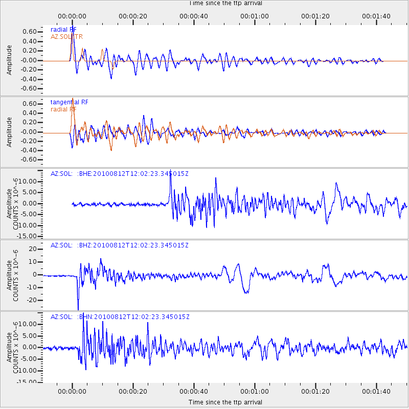
Signal To Noise
| Channel | StoN | STA | LTA |
| AZ:SOL: :BHZ:20100812T12:02:23.345015Z | 46.97684 | 7.375371E-6 | 1.5700016E-7 |
| AZ:SOL: :BHN:20100812T12:02:23.345015Z | 16.375324 | 4.6352366E-6 | 2.830623E-7 |
| AZ:SOL: :BHE:20100812T12:02:23.345015Z | 12.12083 | 4.578489E-6 | 3.7773725E-7 |
| Arrivals |
| Ps | 11 SECOND |
| PpPs | 30 SECOND |
| PsPs/PpSs | 42 SECOND |


