You are here: Home > Network List > AV - Alaska Volcano Observatory Stations List
> Station MTBL Table Top, Makushin Volcano, Alaska > Earthquake Result Viewer
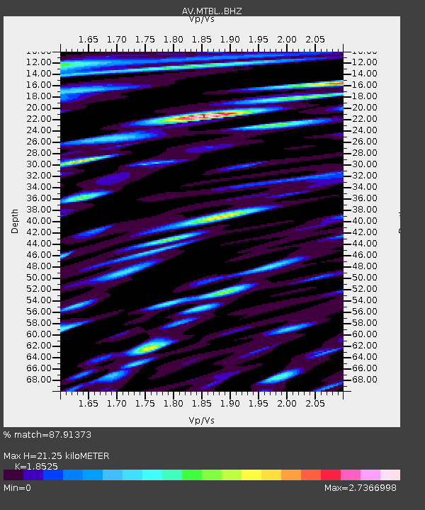
MTBL Table Top, Makushin Volcano, Alaska - Earthquake Result Viewer
| Earthquake location: |
Mindanao, Philippines |
| Earthquake latitude/longitude: |
8.5/126.4 |
| Earthquake time(UTC): |
2023/12/02 (336) 14:37:03 GMT |
| Earthquake Depth: |
33 km |
| Earthquake Magnitude: |
7.6 mww |
| Earthquake Catalog/Contributor: |
NEIC PDE/us |
|
| Network: |
AV Alaska Volcano Observatory |
| Station: |
MTBL Table Top, Makushin Volcano, Alaska |
| Lat/Lon: |
53.97 N/166.68 W |
| Elevation: |
810 m |
|
| Distance: |
69.6 deg |
| Az: |
35.425 deg |
| Baz: |
256.02 deg |
| Ray Param: |
0.055483606 |
| Estimated Moho Depth: |
21.25 km |
| Estimated Crust Vp/Vs: |
1.85 |
| Assumed Crust Vp: |
3.943 km/s |
| Estimated Crust Vs: |
2.129 km/s |
| Estimated Crust Poisson's Ratio: |
0.29 |
|
| Radial Match: |
87.91373 % |
| Radial Bump: |
400 |
| Transverse Match: |
88.81635 % |
| Transverse Bump: |
400 |
| SOD ConfigId: |
33232451 |
| Insert Time: |
2023-12-16 14:46:07.764 +0000 |
| GWidth: |
2.5 |
| Max Bumps: |
400 |
| Tol: |
0.001 |
|

Signal To Noise
| Channel | StoN | STA | LTA |
| AV:MTBL: :BHZ:20231202T14:47:38.979973Z | 14.8998785 | 1.49079E-5 | 1.0005384E-6 |
| AV:MTBL: :BHN:20231202T14:47:38.979973Z | 1.3924645 | 2.0058114E-6 | 1.4404757E-6 |
| AV:MTBL: :BHE:20231202T14:47:38.979973Z | 2.612471 | 7.6052734E-6 | 2.9111416E-6 |
| Arrivals |
| Ps | 4.7 SECOND |
| PpPs | 15 SECOND |
| PsPs/PpSs | 20 SECOND |


