You are here: Home > Network List > AV - Alaska Volcano Observatory Stations List
> Station S12K Black Hills, AK, USA > Earthquake Result Viewer
S12K Black Hills, AK, USA - Earthquake Result Viewer
| Earthquake location: |
Mindanao, Philippines |
| Earthquake latitude/longitude: |
8.5/126.4 |
| Earthquake time(UTC): |
2023/12/02 (336) 14:37:03 GMT |
| Earthquake Depth: |
33 km |
| Earthquake Magnitude: |
7.6 mww |
| Earthquake Catalog/Contributor: |
NEIC PDE/us |
|
| Network: |
AV Alaska Volcano Observatory |
| Station: |
S12K Black Hills, AK, USA |
| Lat/Lon: |
55.70 N/162.06 W |
| Elevation: |
411 m |
|
| Distance: |
72.6 deg |
| Az: |
34.232 deg |
| Baz: |
259.403 deg |
| Ray Param: |
0.053523872 |
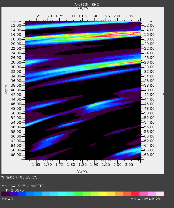
| Estimated Moho Depth: |
15.25 km |
| Estimated Crust Vp/Vs: |
2.07 |
| Assumed Crust Vp: |
5.989 km/s |
| Estimated Crust Vs: |
2.897 km/s |
| Estimated Crust Poisson's Ratio: |
0.35 |
|
| Radial Match: |
90.53775 % |
| Radial Bump: |
400 |
| Transverse Match: |
79.05702 % |
| Transverse Bump: |
400 |
| SOD ConfigId: |
33232451 |
| Insert Time: |
2023-12-16 14:46:47.265 +0000 |
| GWidth: |
2.5 |
| Max Bumps: |
400 |
| Tol: |
0.001 |
|

Signal To Noise
| Channel | StoN | STA | LTA |
| AV:S12K: :BHZ:20231202T14:47:56.975029Z | 12.614223 | 1.1464279E-5 | 9.0883754E-7 |
| AV:S12K: :BHN:20231202T14:47:56.975029Z | 1.5217184 | 1.4661754E-6 | 9.634998E-7 |
| AV:S12K: :BHE:20231202T14:47:56.975029Z | 4.128568 | 4.625107E-6 | 1.120269E-6 |
| Arrivals |
| Ps | 2.8 SECOND |
| PpPs | 7.6 SECOND |
| PsPs/PpSs | 10 SECOND |


