You are here: Home > Network List > AV - Alaska Volcano Observatory Stations List
> Station SPNN North Nagishlamina, Mount Spurr, Alaska > Earthquake Result Viewer
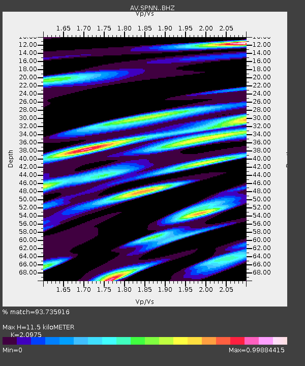
SPNN North Nagishlamina, Mount Spurr, Alaska - Earthquake Result Viewer
| Earthquake location: |
Mindanao, Philippines |
| Earthquake latitude/longitude: |
8.5/126.4 |
| Earthquake time(UTC): |
2023/12/02 (336) 14:37:03 GMT |
| Earthquake Depth: |
33 km |
| Earthquake Magnitude: |
7.6 mww |
| Earthquake Catalog/Contributor: |
NEIC PDE/us |
|
| Network: |
AV Alaska Volcano Observatory |
| Station: |
SPNN North Nagishlamina, Mount Spurr, Alaska |
| Lat/Lon: |
61.37 N/152.70 W |
| Elevation: |
1666 m |
|
| Distance: |
78.2 deg |
| Az: |
29.069 deg |
| Baz: |
266.082 deg |
| Ray Param: |
0.04978 |
| Estimated Moho Depth: |
11.5 km |
| Estimated Crust Vp/Vs: |
2.10 |
| Assumed Crust Vp: |
6.566 km/s |
| Estimated Crust Vs: |
3.13 km/s |
| Estimated Crust Poisson's Ratio: |
0.35 |
|
| Radial Match: |
93.735916 % |
| Radial Bump: |
400 |
| Transverse Match: |
90.13628 % |
| Transverse Bump: |
400 |
| SOD ConfigId: |
33232451 |
| Insert Time: |
2023-12-16 14:46:54.453 +0000 |
| GWidth: |
2.5 |
| Max Bumps: |
400 |
| Tol: |
0.001 |
|

Signal To Noise
| Channel | StoN | STA | LTA |
| AV:SPNN: :BHZ:20231202T14:48:28.960015Z | 17.323374 | 6.864412E-6 | 3.9625144E-7 |
| AV:SPNN: :BHN:20231202T14:48:28.960015Z | 0.65592563 | 2.6526504E-7 | 4.044133E-7 |
| AV:SPNN: :BHE:20231202T14:48:28.960015Z | 5.286748 | 2.202251E-6 | 4.165606E-7 |
| Arrivals |
| Ps | 2.0 SECOND |
| PpPs | 5.3 SECOND |
| PsPs/PpSs | 7.3 SECOND |


