You are here: Home > Network List > AV - Alaska Volcano Observatory Stations List
> Station TASO South, Tanaga Volcano, Alaska > Earthquake Result Viewer
TASO South, Tanaga Volcano, Alaska - Earthquake Result Viewer
| Earthquake location: |
Mindanao, Philippines |
| Earthquake latitude/longitude: |
8.5/126.4 |
| Earthquake time(UTC): |
2023/12/02 (336) 14:37:03 GMT |
| Earthquake Depth: |
33 km |
| Earthquake Magnitude: |
7.6 mww |
| Earthquake Catalog/Contributor: |
NEIC PDE/us |
|
| Network: |
AV Alaska Volcano Observatory |
| Station: |
TASO South, Tanaga Volcano, Alaska |
| Lat/Lon: |
51.85 N/178.15 W |
| Elevation: |
690 m |
|
| Distance: |
62.4 deg |
| Az: |
35.193 deg |
| Baz: |
246.79 deg |
| Ray Param: |
0.060221862 |
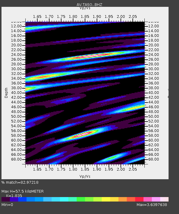
| Estimated Moho Depth: |
57.5 km |
| Estimated Crust Vp/Vs: |
1.84 |
| Assumed Crust Vp: |
6.048 km/s |
| Estimated Crust Vs: |
3.296 km/s |
| Estimated Crust Poisson's Ratio: |
0.29 |
|
| Radial Match: |
82.97218 % |
| Radial Bump: |
400 |
| Transverse Match: |
77.324036 % |
| Transverse Bump: |
400 |
| SOD ConfigId: |
33232451 |
| Insert Time: |
2023-12-16 14:47:09.137 +0000 |
| GWidth: |
2.5 |
| Max Bumps: |
400 |
| Tol: |
0.001 |
|

Signal To Noise
| Channel | StoN | STA | LTA |
| AV:TASO: :BHZ:20231202T14:46:52.518975Z | 5.775386 | 1.6192733E-5 | 2.8037489E-6 |
| AV:TASO: :BHN:20231202T14:46:52.518975Z | 1.0448624 | 5.398472E-6 | 5.166682E-6 |
| AV:TASO: :BHE:20231202T14:46:52.518975Z | 1.3886359 | 6.588872E-6 | 4.744852E-6 |
| Arrivals |
| Ps | 8.2 SECOND |
| PpPs | 26 SECOND |
| PsPs/PpSs | 34 SECOND |


