You are here: Home > Network List > G - GEOSCOPE Stations List
> Station ATD Arta Cave - Arta, Republic of Djibouti > Earthquake Result Viewer
ATD Arta Cave - Arta, Republic of Djibouti - Earthquake Result Viewer
| Earthquake location: |
Mindanao, Philippines |
| Earthquake latitude/longitude: |
8.5/126.4 |
| Earthquake time(UTC): |
2023/12/02 (336) 14:37:03 GMT |
| Earthquake Depth: |
33 km |
| Earthquake Magnitude: |
7.6 mww |
| Earthquake Catalog/Contributor: |
NEIC PDE/us |
|
| Network: |
G GEOSCOPE |
| Station: |
ATD Arta Cave - Arta, Republic of Djibouti |
| Lat/Lon: |
11.53 N/42.85 E |
| Elevation: |
610 m |
|
| Distance: |
82.1 deg |
| Az: |
280.491 deg |
| Baz: |
82.898 deg |
| Ray Param: |
0.047074992 |
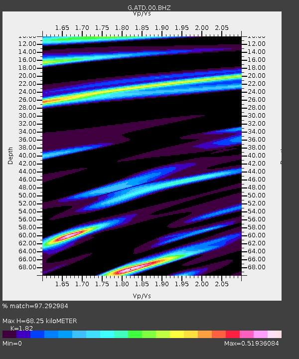
| Estimated Moho Depth: |
68.25 km |
| Estimated Crust Vp/Vs: |
1.82 |
| Assumed Crust Vp: |
6.375 km/s |
| Estimated Crust Vs: |
3.503 km/s |
| Estimated Crust Poisson's Ratio: |
0.28 |
|
| Radial Match: |
97.292984 % |
| Radial Bump: |
297 |
| Transverse Match: |
87.52816 % |
| Transverse Bump: |
400 |
| SOD ConfigId: |
33232451 |
| Insert Time: |
2023-12-16 14:49:31.728 +0000 |
| GWidth: |
2.5 |
| Max Bumps: |
400 |
| Tol: |
0.001 |
|
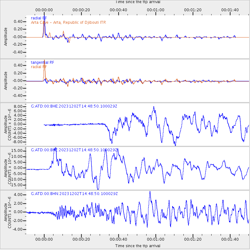
Signal To Noise
| Channel | StoN | STA | LTA |
| G:ATD:00:BHZ:20231202T14:48:50.100029Z | 9.136074 | 2.5187164E-6 | 2.7568916E-7 |
| G:ATD:00:BHN:20231202T14:48:50.100029Z | 1.4183248 | 1.2313764E-7 | 8.6819064E-8 |
| G:ATD:00:BHE:20231202T14:48:50.100029Z | 5.3717637 | 9.560321E-7 | 1.7797359E-7 |
| Arrivals |
| Ps | 9.0 SECOND |
| PpPs | 29 SECOND |
| PsPs/PpSs | 38 SECOND |


