You are here: Home > Network List > G - GEOSCOPE Stations List
> Station CRZF Port Alfred, Crozet, South Indian Ocean > Earthquake Result Viewer
CRZF Port Alfred, Crozet, South Indian Ocean - Earthquake Result Viewer
| Earthquake location: |
Mindanao, Philippines |
| Earthquake latitude/longitude: |
8.5/126.4 |
| Earthquake time(UTC): |
2023/12/02 (336) 14:37:03 GMT |
| Earthquake Depth: |
33 km |
| Earthquake Magnitude: |
7.6 mww |
| Earthquake Catalog/Contributor: |
NEIC PDE/us |
|
| Network: |
G GEOSCOPE |
| Station: |
CRZF Port Alfred, Crozet, South Indian Ocean |
| Lat/Lon: |
46.43 S/51.86 E |
| Elevation: |
140 m |
|
| Distance: |
85.7 deg |
| Az: |
221.967 deg |
| Baz: |
72.989 deg |
| Ray Param: |
0.04455375 |
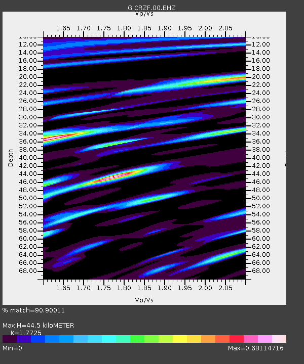
| Estimated Moho Depth: |
44.5 km |
| Estimated Crust Vp/Vs: |
1.77 |
| Assumed Crust Vp: |
4.802 km/s |
| Estimated Crust Vs: |
2.709 km/s |
| Estimated Crust Poisson's Ratio: |
0.27 |
|
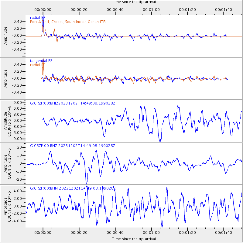
| Radial Match: |
90.90011 % |
| Radial Bump: |
349 |
| Transverse Match: |
69.922295 % |
| Transverse Bump: |
400 |
| SOD ConfigId: |
33232451 |
| Insert Time: |
2023-12-16 14:49:35.809 +0000 |
| GWidth: |
2.5 |
| Max Bumps: |
400 |
| Tol: |
0.001 |
|
Signal To Noise
| Channel | StoN | STA | LTA |
| G:CRZF:00:BHZ:20231202T14:49:08.199028Z | 9.575372 | 7.441777E-6 | 7.771789E-7 |
| G:CRZF:00:BHN:20231202T14:49:08.199028Z | 1.5335695 | 1.642599E-6 | 1.0710953E-6 |
| G:CRZF:00:BHE:20231202T14:49:08.199028Z | 3.683541 | 3.6160307E-6 | 9.816724E-7 |
| Arrivals |
| Ps | 7.3 SECOND |
| PpPs | 25 SECOND |
| PsPs/PpSs | 33 SECOND |


