You are here: Home > Network List > CI - Caltech Regional Seismic Network Stations List
> Station VTV Victorville, California, USA > Earthquake Result Viewer
VTV Victorville, California, USA - Earthquake Result Viewer
| Earthquake location: |
Ecuador |
| Earthquake latitude/longitude: |
-1.3/-77.3 |
| Earthquake time(UTC): |
2010/08/12 (224) 11:54:15 GMT |
| Earthquake Depth: |
207 km |
| Earthquake Magnitude: |
6.4 MB, 7.1 MW, 7.1 MW |
| Earthquake Catalog/Contributor: |
WHDF/NEIC |
|
| Network: |
CI Caltech Regional Seismic Network |
| Station: |
VTV Victorville, California, USA |
| Lat/Lon: |
34.56 N/117.33 W |
| Elevation: |
812 m |
|
| Distance: |
51.7 deg |
| Az: |
317.461 deg |
| Baz: |
125.014 deg |
| Ray Param: |
0.06648568 |
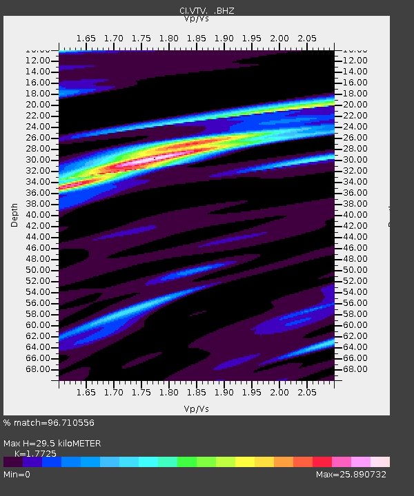
| Estimated Moho Depth: |
29.5 km |
| Estimated Crust Vp/Vs: |
1.77 |
| Assumed Crust Vp: |
6.276 km/s |
| Estimated Crust Vs: |
3.541 km/s |
| Estimated Crust Poisson's Ratio: |
0.27 |
|
| Radial Match: |
96.710556 % |
| Radial Bump: |
400 |
| Transverse Match: |
87.91568 % |
| Transverse Bump: |
400 |
| SOD ConfigId: |
319893 |
| Insert Time: |
2011-01-05 20:18:10.179 +0000 |
| GWidth: |
2.5 |
| Max Bumps: |
400 |
| Tol: |
0.001 |
|

Signal To Noise
| Channel | StoN | STA | LTA |
| CI:VTV: :BHZ:20100812T12:02:30.955Z | 26.245857 | 1.6685806E-7 | 6.3575007E-9 |
| CI:VTV: :BHN:20100812T12:02:30.955Z | 6.4495397 | 1.4996416E-6 | 2.3251917E-7 |
| CI:VTV: :BHE:20100812T12:02:30.955Z | 7.1853404 | 1.8564531E-6 | 2.5836675E-7 |
| Arrivals |
| Ps | 3.8 SECOND |
| PpPs | 12 SECOND |
| PsPs/PpSs | 16 SECOND |


