You are here: Home > Network List > CI - Caltech Regional Seismic Network Stations List
> Station OSI Osito Adit, California, USA > Earthquake Result Viewer
OSI Osito Adit, California, USA - Earthquake Result Viewer

| Earthquake location: |
Ecuador |
| Earthquake latitude/longitude: |
-1.3/-77.3 |
| Earthquake time(UTC): |
2010/08/12 (224) 11:54:15 GMT |
| Earthquake Depth: |
207 km |
| Earthquake Magnitude: |
6.4 MB, 7.1 MW, 7.1 MW |
| Earthquake Catalog/Contributor: |
WHDF/NEIC |
|
| Network: |
CI Caltech Regional Seismic Network |
| Station: |
OSI Osito Adit, California, USA |
| Lat/Lon: |
34.61 N/118.72 W |
| Elevation: |
706 m |
|
| Distance: |
52.7 deg |
| Az: |
316.695 deg |
| Baz: |
123.758 deg |
| Ray Param: |
0.06583936 |
| Estimated Moho Depth: |
18.25 km |
| Estimated Crust Vp/Vs: |
2.10 |
| Assumed Crust Vp: |
6.1 km/s |
| Estimated Crust Vs: |
2.908 km/s |
| Estimated Crust Poisson's Ratio: |
0.35 |
|
| Radial Match: |
94.12814 % |
| Radial Bump: |
400 |
| Transverse Match: |
81.90009 % |
| Transverse Bump: |
400 |
| SOD ConfigId: |
319893 |
| Insert Time: |
2011-01-05 20:18:23.522 +0000 |
| GWidth: |
2.5 |
| Max Bumps: |
400 |
| Tol: |
0.001 |
|
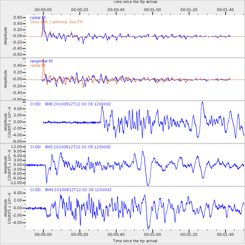
Signal To Noise
| Channel | StoN | STA | LTA |
| CI:OSI: :BHZ:20100812T12:02:38.120009Z | 29.978819 | 4.6078053E-6 | 1.5370203E-7 |
| CI:OSI: :BHN:20100812T12:02:38.120009Z | 11.85167 | 1.3005966E-6 | 1.0973952E-7 |
| CI:OSI: :BHE:20100812T12:02:38.120009Z | 17.553677 | 1.9703546E-6 | 1.1224741E-7 |
| Arrivals |
| Ps | 3.4 SECOND |
| PpPs | 8.9 SECOND |
| PsPs/PpSs | 12 SECOND |


