You are here: Home > Network List > CI - Caltech Regional Seismic Network Stations List
> Station HEC Hector, Baker, CA, USA > Earthquake Result Viewer
HEC Hector, Baker, CA, USA - Earthquake Result Viewer

| Earthquake location: |
Ecuador |
| Earthquake latitude/longitude: |
-1.3/-77.3 |
| Earthquake time(UTC): |
2010/08/12 (224) 11:54:15 GMT |
| Earthquake Depth: |
207 km |
| Earthquake Magnitude: |
6.4 MB, 7.1 MW, 7.1 MW |
| Earthquake Catalog/Contributor: |
WHDF/NEIC |
|
| Network: |
CI Caltech Regional Seismic Network |
| Station: |
HEC Hector, Baker, CA, USA |
| Lat/Lon: |
34.83 N/116.33 W |
| Elevation: |
920 m |
|
| Distance: |
51.2 deg |
| Az: |
318.349 deg |
| Baz: |
126.131 deg |
| Ray Param: |
0.06680929 |
| Estimated Moho Depth: |
29.75 km |
| Estimated Crust Vp/Vs: |
1.71 |
| Assumed Crust Vp: |
6.276 km/s |
| Estimated Crust Vs: |
3.675 km/s |
| Estimated Crust Poisson's Ratio: |
0.24 |
|
| Radial Match: |
96.03591 % |
| Radial Bump: |
400 |
| Transverse Match: |
81.597786 % |
| Transverse Bump: |
400 |
| SOD ConfigId: |
319893 |
| Insert Time: |
2011-01-05 20:18:47.787 +0000 |
| GWidth: |
2.5 |
| Max Bumps: |
400 |
| Tol: |
0.001 |
|
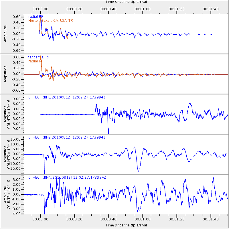
Signal To Noise
| Channel | StoN | STA | LTA |
| CI:HEC: :BHZ:20100812T12:02:27.173994Z | 71.08922 | 5.026108E-6 | 7.0701404E-8 |
| CI:HEC: :BHN:20100812T12:02:27.173994Z | 25.065056 | 1.2289742E-6 | 4.9031378E-8 |
| CI:HEC: :BHE:20100812T12:02:27.173994Z | 30.433725 | 2.2617749E-6 | 7.4318045E-8 |
| Arrivals |
| Ps | 3.5 SECOND |
| PpPs | 12 SECOND |
| PsPs/PpSs | 16 SECOND |


