You are here: Home > Network List > CI - Caltech Regional Seismic Network Stations List
> Station MPM Manuel Prospect Mine, California, USA > Earthquake Result Viewer
MPM Manuel Prospect Mine, California, USA - Earthquake Result Viewer
| Earthquake location: |
Ecuador |
| Earthquake latitude/longitude: |
-1.3/-77.3 |
| Earthquake time(UTC): |
2010/08/12 (224) 11:54:15 GMT |
| Earthquake Depth: |
207 km |
| Earthquake Magnitude: |
6.4 MB, 7.1 MW, 7.1 MW |
| Earthquake Catalog/Contributor: |
WHDF/NEIC |
|
| Network: |
CI Caltech Regional Seismic Network |
| Station: |
MPM Manuel Prospect Mine, California, USA |
| Lat/Lon: |
36.06 N/117.49 W |
| Elevation: |
185 m |
|
| Distance: |
52.7 deg |
| Az: |
318.906 deg |
| Baz: |
125.808 deg |
| Ray Param: |
0.065844245 |
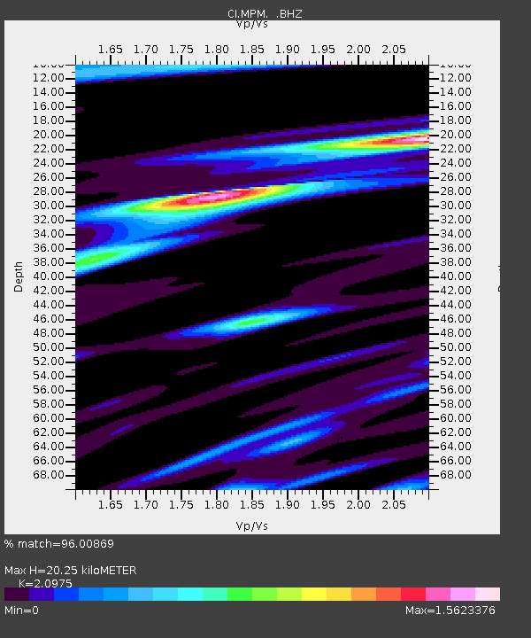
| Estimated Moho Depth: |
20.25 km |
| Estimated Crust Vp/Vs: |
2.10 |
| Assumed Crust Vp: |
6.279 km/s |
| Estimated Crust Vs: |
2.993 km/s |
| Estimated Crust Poisson's Ratio: |
0.35 |
|
| Radial Match: |
96.00869 % |
| Radial Bump: |
400 |
| Transverse Match: |
86.96585 % |
| Transverse Bump: |
400 |
| SOD ConfigId: |
319893 |
| Insert Time: |
2011-01-05 20:19:01.732 +0000 |
| GWidth: |
2.5 |
| Max Bumps: |
400 |
| Tol: |
0.001 |
|
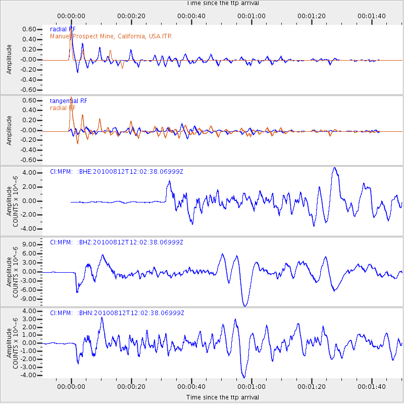
Signal To Noise
| Channel | StoN | STA | LTA |
| CI:MPM: :BHZ:20100812T12:02:38.06999Z | 32.972633 | 2.981265E-6 | 9.041634E-8 |
| CI:MPM: :BHN:20100812T12:02:38.06999Z | 20.225307 | 1.0557332E-6 | 5.219862E-8 |
| CI:MPM: :BHE:20100812T12:02:38.06999Z | 24.130266 | 1.4133774E-6 | 5.8572805E-8 |
| Arrivals |
| Ps | 3.7 SECOND |
| PpPs | 9.6 SECOND |
| PsPs/PpSs | 13 SECOND |


