You are here: Home > Network List > CN - Canadian National Seismograph Network Stations List
> Station WHY Whitehorse, YT, CA > Earthquake Result Viewer
WHY Whitehorse, YT, CA - Earthquake Result Viewer

| Earthquake location: |
Philippine Islands Region |
| Earthquake latitude/longitude: |
8.3/127.0 |
| Earthquake time(UTC): |
2023/12/02 (336) 15:06:46 GMT |
| Earthquake Depth: |
60 km |
| Earthquake Magnitude: |
5.8 mb |
| Earthquake Catalog/Contributor: |
NEIC PDE/us |
|
| Network: |
CN Canadian National Seismograph Network |
| Station: |
WHY Whitehorse, YT, CA |
| Lat/Lon: |
60.66 N/134.88 W |
| Elevation: |
1273 m |
|
| Distance: |
86.8 deg |
| Az: |
29.233 deg |
| Baz: |
281.091 deg |
| Ray Param: |
0.043704517 |
| Estimated Moho Depth: |
36.75 km |
| Estimated Crust Vp/Vs: |
1.80 |
| Assumed Crust Vp: |
6.419 km/s |
| Estimated Crust Vs: |
3.566 km/s |
| Estimated Crust Poisson's Ratio: |
0.28 |
|
| Radial Match: |
95.80917 % |
| Radial Bump: |
330 |
| Transverse Match: |
82.84503 % |
| Transverse Bump: |
400 |
| SOD ConfigId: |
33232451 |
| Insert Time: |
2023-12-16 15:13:37.002 +0000 |
| GWidth: |
2.5 |
| Max Bumps: |
400 |
| Tol: |
0.001 |
|
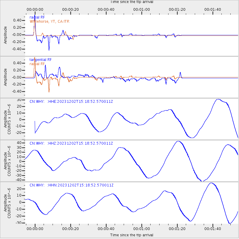
Signal To Noise
| Channel | StoN | STA | LTA |
| CN:WHY: :HHZ:20231202T15:18:52.570011Z | 5.003333 | 2.443818E-5 | 4.8843804E-6 |
| CN:WHY: :HHN:20231202T15:18:52.570011Z | 0.7907966 | 8.949933E-6 | 1.1317617E-5 |
| CN:WHY: :HHE:20231202T15:18:52.570011Z | 1.2962942 | 8.983007E-6 | 6.9297603E-6 |
| Arrivals |
| Ps | 4.7 SECOND |
| PpPs | 16 SECOND |
| PsPs/PpSs | 20 SECOND |


