You are here: Home > Network List > DK - Danish Seismological Network Stations List
> Station TULEG Thule Air Base, Greenland > Earthquake Result Viewer
TULEG Thule Air Base, Greenland - Earthquake Result Viewer
| Earthquake location: |
Ecuador |
| Earthquake latitude/longitude: |
-1.3/-77.3 |
| Earthquake time(UTC): |
2010/08/12 (224) 11:54:15 GMT |
| Earthquake Depth: |
207 km |
| Earthquake Magnitude: |
6.4 MB, 7.1 MW, 7.1 MW |
| Earthquake Catalog/Contributor: |
WHDF/NEIC |
|
| Network: |
DK Danish Seismological Network |
| Station: |
TULEG Thule Air Base, Greenland |
| Lat/Lon: |
76.54 N/68.82 W |
| Elevation: |
38 m |
|
| Distance: |
77.9 deg |
| Az: |
2.026 deg |
| Baz: |
188.676 deg |
| Ray Param: |
0.049505953 |
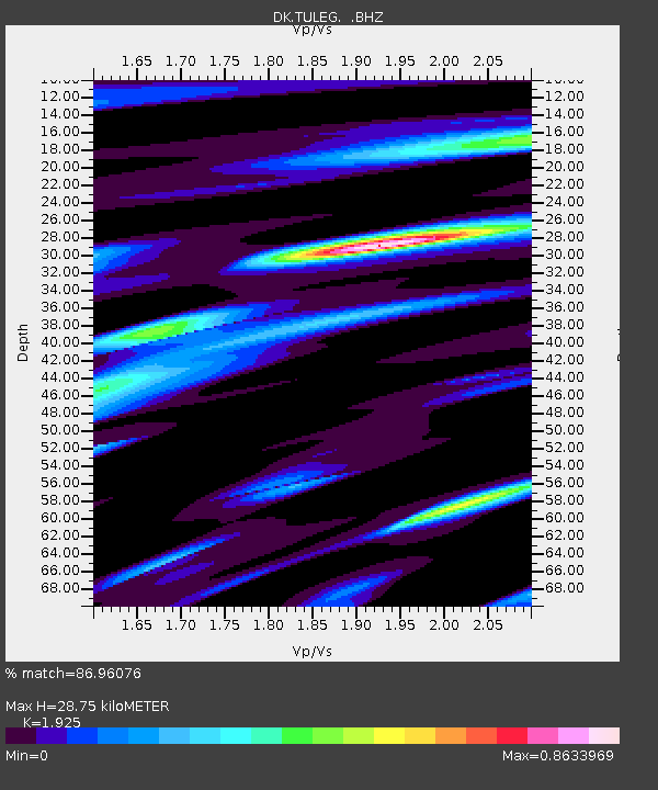
| Estimated Moho Depth: |
28.75 km |
| Estimated Crust Vp/Vs: |
1.92 |
| Assumed Crust Vp: |
6.459 km/s |
| Estimated Crust Vs: |
3.356 km/s |
| Estimated Crust Poisson's Ratio: |
0.32 |
|
| Radial Match: |
86.96076 % |
| Radial Bump: |
400 |
| Transverse Match: |
81.85199 % |
| Transverse Bump: |
400 |
| SOD ConfigId: |
319893 |
| Insert Time: |
2011-01-05 20:22:40.568 +0000 |
| GWidth: |
2.5 |
| Max Bumps: |
400 |
| Tol: |
0.001 |
|

Signal To Noise
| Channel | StoN | STA | LTA |
| DK:TULEG: :BHZ:20100812T12:05:19.10002Z | 65.33935 | 5.7252673E-6 | 8.7623576E-8 |
| DK:TULEG: :BHN:20100812T12:05:19.10002Z | 2.156354 | 1.7089517E-6 | 7.9251913E-7 |
| DK:TULEG: :BHE:20100812T12:05:19.10002Z | 1.321532 | 5.389901E-7 | 4.0785247E-7 |
| Arrivals |
| Ps | 4.2 SECOND |
| PpPs | 13 SECOND |
| PsPs/PpSs | 17 SECOND |


