You are here: Home > Network List > G - GEOSCOPE Stations List
> Station TAOE Taiohae, Marquises islands > Earthquake Result Viewer
TAOE Taiohae, Marquises islands - Earthquake Result Viewer
| Earthquake location: |
Ecuador |
| Earthquake latitude/longitude: |
-1.3/-77.3 |
| Earthquake time(UTC): |
2010/08/12 (224) 11:54:15 GMT |
| Earthquake Depth: |
207 km |
| Earthquake Magnitude: |
6.4 MB, 7.1 MW, 7.1 MW |
| Earthquake Catalog/Contributor: |
WHDF/NEIC |
|
| Network: |
G GEOSCOPE |
| Station: |
TAOE Taiohae, Marquises islands |
| Lat/Lon: |
8.85 S/140.15 W |
| Elevation: |
800 m |
|
| Distance: |
63.0 deg |
| Az: |
260.763 deg |
| Baz: |
86.905 deg |
| Ray Param: |
0.059239782 |
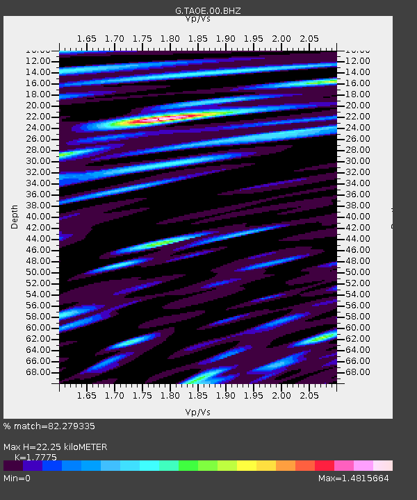
| Estimated Moho Depth: |
22.25 km |
| Estimated Crust Vp/Vs: |
1.78 |
| Assumed Crust Vp: |
4.24 km/s |
| Estimated Crust Vs: |
2.385 km/s |
| Estimated Crust Poisson's Ratio: |
0.27 |
|
| Radial Match: |
82.279335 % |
| Radial Bump: |
396 |
| Transverse Match: |
72.06821 % |
| Transverse Bump: |
400 |
| SOD ConfigId: |
319893 |
| Insert Time: |
2011-01-05 20:22:52.335 +0000 |
| GWidth: |
2.5 |
| Max Bumps: |
400 |
| Tol: |
0.001 |
|
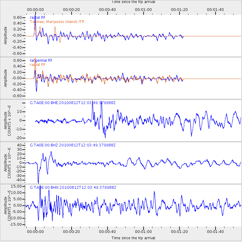
Signal To Noise
| Channel | StoN | STA | LTA |
| G:TAOE:00:BHZ:20100812T12:03:49.379988Z | 11.8277025 | 1.5631967E-5 | 1.3216402E-6 |
| G:TAOE:00:BHN:20100812T12:03:49.379988Z | 3.7865589 | 5.750723E-6 | 1.5187202E-6 |
| G:TAOE:00:BHE:20100812T12:03:49.379988Z | 6.0887294 | 6.581164E-6 | 1.0808765E-6 |
| Arrivals |
| Ps | 4.2 SECOND |
| PpPs | 14 SECOND |
| PsPs/PpSs | 18 SECOND |


