You are here: Home > Network List > GS - US Geological Survey Networks Stations List
> Station KAN05 Bluff City North Station > Earthquake Result Viewer
KAN05 Bluff City North Station - Earthquake Result Viewer

| Earthquake location: |
Central Peru |
| Earthquake latitude/longitude: |
-14.7/-70.1 |
| Earthquake time(UTC): |
2019/03/01 (060) 08:50:41 GMT |
| Earthquake Depth: |
257 km |
| Earthquake Magnitude: |
7.0 mww |
| Earthquake Catalog/Contributor: |
NEIC PDE/us |
|
| Network: |
GS US Geological Survey Networks |
| Station: |
KAN05 Bluff City North Station |
| Lat/Lon: |
37.11 N/97.87 W |
| Elevation: |
348 m |
|
| Distance: |
57.8 deg |
| Az: |
333.897 deg |
| Baz: |
147.817 deg |
| Ray Param: |
0.062401466 |
| Estimated Moho Depth: |
46.25 km |
| Estimated Crust Vp/Vs: |
1.60 |
| Assumed Crust Vp: |
6.483 km/s |
| Estimated Crust Vs: |
4.052 km/s |
| Estimated Crust Poisson's Ratio: |
0.18 |
|
| Radial Match: |
94.624176 % |
| Radial Bump: |
398 |
| Transverse Match: |
86.38128 % |
| Transverse Bump: |
400 |
| SOD ConfigId: |
3313551 |
| Insert Time: |
2019-03-15 09:03:53.457 +0000 |
| GWidth: |
2.5 |
| Max Bumps: |
400 |
| Tol: |
0.001 |
|
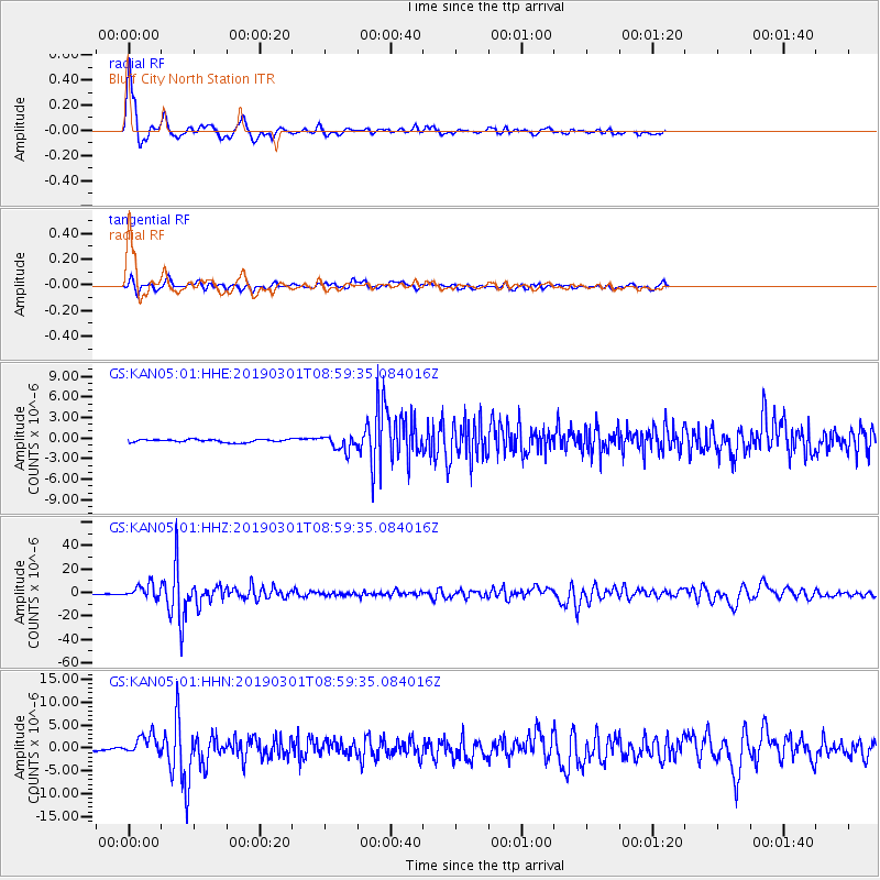
Signal To Noise
| Channel | StoN | STA | LTA |
| GS:KAN05:01:HHZ:20190301T08:59:35.084016Z | 17.334452 | 5.9459644E-6 | 3.4301428E-7 |
| GS:KAN05:01:HHN:20190301T08:59:35.084016Z | 6.459433 | 2.1958738E-6 | 3.3994837E-7 |
| GS:KAN05:01:HHE:20190301T08:59:35.084016Z | 5.2002516 | 1.0723139E-6 | 2.0620423E-7 |
| Arrivals |
| Ps | 4.5 SECOND |
| PpPs | 18 SECOND |
| PsPs/PpSs | 22 SECOND |


