You are here: Home > Network List > GS - US Geological Survey Networks Stations List
> Station KAN12 Houston Home > Earthquake Result Viewer
KAN12 Houston Home - Earthquake Result Viewer
| Earthquake location: |
Central Peru |
| Earthquake latitude/longitude: |
-14.7/-70.1 |
| Earthquake time(UTC): |
2019/03/01 (060) 08:50:41 GMT |
| Earthquake Depth: |
257 km |
| Earthquake Magnitude: |
7.0 mww |
| Earthquake Catalog/Contributor: |
NEIC PDE/us |
|
| Network: |
GS US Geological Survey Networks |
| Station: |
KAN12 Houston Home |
| Lat/Lon: |
37.30 N/98.00 W |
| Elevation: |
426 m |
|
| Distance: |
58.0 deg |
| Az: |
333.915 deg |
| Baz: |
147.751 deg |
| Ray Param: |
0.062263273 |
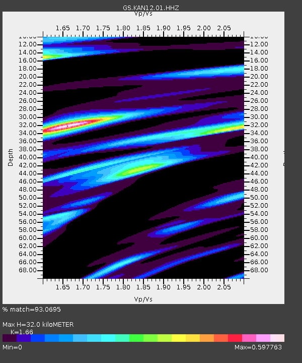
| Estimated Moho Depth: |
32.0 km |
| Estimated Crust Vp/Vs: |
1.66 |
| Assumed Crust Vp: |
6.483 km/s |
| Estimated Crust Vs: |
3.905 km/s |
| Estimated Crust Poisson's Ratio: |
0.22 |
|
| Radial Match: |
93.0695 % |
| Radial Bump: |
291 |
| Transverse Match: |
70.36646 % |
| Transverse Bump: |
400 |
| SOD ConfigId: |
3313551 |
| Insert Time: |
2019-03-15 09:03:59.913 +0000 |
| GWidth: |
2.5 |
| Max Bumps: |
400 |
| Tol: |
0.001 |
|

Signal To Noise
| Channel | StoN | STA | LTA |
| GS:KAN12:01:HHZ:20190301T08:59:36.555024Z | 25.821758 | 5.7788397E-6 | 2.2379731E-7 |
| GS:KAN12:01:HHN:20190301T08:59:36.555024Z | 10.988148 | 2.175445E-6 | 1.9798104E-7 |
| GS:KAN12:01:HHE:20190301T08:59:36.555024Z | 7.7825027 | 1.3813373E-6 | 1.7749268E-7 |
| Arrivals |
| Ps | 3.4 SECOND |
| PpPs | 12 SECOND |
| PsPs/PpSs | 16 SECOND |


