You are here: Home > Network List > GS - US Geological Survey Networks Stations List
> Station KAN13 Rinehart Farm > Earthquake Result Viewer
KAN13 Rinehart Farm - Earthquake Result Viewer

| Earthquake location: |
Central Peru |
| Earthquake latitude/longitude: |
-14.7/-70.1 |
| Earthquake time(UTC): |
2019/03/01 (060) 08:50:41 GMT |
| Earthquake Depth: |
257 km |
| Earthquake Magnitude: |
7.0 mww |
| Earthquake Catalog/Contributor: |
NEIC PDE/us |
|
| Network: |
GS US Geological Survey Networks |
| Station: |
KAN13 Rinehart Farm |
| Lat/Lon: |
37.01 N/97.48 W |
| Elevation: |
340 m |
|
| Distance: |
57.5 deg |
| Az: |
334.154 deg |
| Baz: |
148.192 deg |
| Ray Param: |
0.06256118 |
| Estimated Moho Depth: |
57.75 km |
| Estimated Crust Vp/Vs: |
1.72 |
| Assumed Crust Vp: |
6.483 km/s |
| Estimated Crust Vs: |
3.763 km/s |
| Estimated Crust Poisson's Ratio: |
0.25 |
|
| Radial Match: |
93.51354 % |
| Radial Bump: |
344 |
| Transverse Match: |
63.75369 % |
| Transverse Bump: |
400 |
| SOD ConfigId: |
3313551 |
| Insert Time: |
2019-03-15 09:04:02.038 +0000 |
| GWidth: |
2.5 |
| Max Bumps: |
400 |
| Tol: |
0.001 |
|
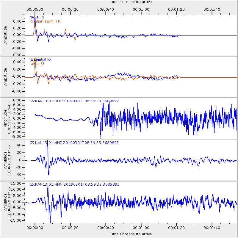
Signal To Noise
| Channel | StoN | STA | LTA |
| GS:KAN13:01:HHZ:20190301T08:59:33.368989Z | 13.868691 | 5.432567E-6 | 3.9171445E-7 |
| GS:KAN13:01:HHN:20190301T08:59:33.368989Z | 7.7425323 | 2.0651876E-6 | 2.6673285E-7 |
| GS:KAN13:01:HHE:20190301T08:59:33.368989Z | 1.7771233 | 1.4609708E-6 | 8.2209874E-7 |
| Arrivals |
| Ps | 6.8 SECOND |
| PpPs | 23 SECOND |
| PsPs/PpSs | 30 SECOND |


