You are here: Home > Network List > II - Global Seismograph Network (GSN - IRIS/IDA) Stations List
> Station BFO Black Forest Observatory, Schiltach, Germany > Earthquake Result Viewer
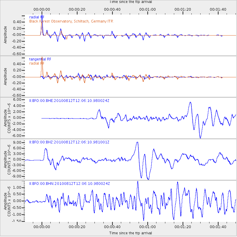
BFO Black Forest Observatory, Schiltach, Germany - Earthquake Result Viewer

| Earthquake location: |
Ecuador |
| Earthquake latitude/longitude: |
-1.3/-77.3 |
| Earthquake time(UTC): |
2010/08/12 (224) 11:54:15 GMT |
| Earthquake Depth: |
207 km |
| Earthquake Magnitude: |
6.4 MB, 7.1 MW, 7.1 MW |
| Earthquake Catalog/Contributor: |
WHDF/NEIC |
|
| Network: |
II Global Seismograph Network (GSN - IRIS/IDA) |
| Station: |
BFO Black Forest Observatory, Schiltach, Germany |
| Lat/Lon: |
48.33 N/8.33 E |
| Elevation: |
589 m |
|
| Distance: |
88.0 deg |
| Az: |
41.741 deg |
| Baz: |
265.91 deg |
| Ray Param: |
0.042406578 |
| Estimated Moho Depth: |
25.75 km |
| Estimated Crust Vp/Vs: |
1.64 |
| Assumed Crust Vp: |
6.264 km/s |
| Estimated Crust Vs: |
3.813 km/s |
| Estimated Crust Poisson's Ratio: |
0.21 |
|
| Radial Match: |
97.491295 % |
| Radial Bump: |
267 |
| Transverse Match: |
88.451195 % |
| Transverse Bump: |
400 |
| SOD ConfigId: |
319893 |
| Insert Time: |
2011-01-05 20:23:44.406 +0000 |
| GWidth: |
2.5 |
| Max Bumps: |
400 |
| Tol: |
0.001 |
|
Signal To Noise
| Channel | StoN | STA | LTA |
| II:BFO:00:BHZ:20100812T12:06:10.981001Z | 43.54735 | 3.0381577E-6 | 6.976676E-8 |
| II:BFO:00:BHN:20100812T12:06:10.980024Z | 4.026339 | 2.2463004E-7 | 5.5790146E-8 |
| II:BFO:00:BHE:20100812T12:06:10.980024Z | 33.742214 | 1.3621317E-6 | 4.036877E-8 |
| Arrivals |
| Ps | 2.7 SECOND |
| PpPs | 11 SECOND |
| PsPs/PpSs | 13 SECOND |


