You are here: Home > Network List > GS - US Geological Survey Networks Stations List
> Station OK051 E0350 and S34600 Roads, Ralston, OK > Earthquake Result Viewer
OK051 E0350 and S34600 Roads, Ralston, OK - Earthquake Result Viewer
| Earthquake location: |
Central Peru |
| Earthquake latitude/longitude: |
-14.7/-70.1 |
| Earthquake time(UTC): |
2019/03/01 (060) 08:50:41 GMT |
| Earthquake Depth: |
257 km |
| Earthquake Magnitude: |
7.0 mww |
| Earthquake Catalog/Contributor: |
NEIC PDE/us |
|
| Network: |
GS US Geological Survey Networks |
| Station: |
OK051 E0350 and S34600 Roads, Ralston, OK |
| Lat/Lon: |
36.51 N/96.84 W |
| Elevation: |
263 m |
|
| Distance: |
56.8 deg |
| Az: |
334.361 deg |
| Baz: |
148.686 deg |
| Ray Param: |
0.063009806 |
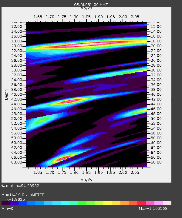
| Estimated Moho Depth: |
19.0 km |
| Estimated Crust Vp/Vs: |
1.86 |
| Assumed Crust Vp: |
6.483 km/s |
| Estimated Crust Vs: |
3.481 km/s |
| Estimated Crust Poisson's Ratio: |
0.30 |
|
| Radial Match: |
94.28932 % |
| Radial Bump: |
293 |
| Transverse Match: |
72.8389 % |
| Transverse Bump: |
400 |
| SOD ConfigId: |
3313551 |
| Insert Time: |
2019-03-15 09:04:15.490 +0000 |
| GWidth: |
2.5 |
| Max Bumps: |
400 |
| Tol: |
0.001 |
|

Signal To Noise
| Channel | StoN | STA | LTA |
| GS:OK051:00:HHZ:20190301T08:59:28.480012Z | 19.951603 | 5.268843E-6 | 2.640812E-7 |
| GS:OK051:00:HH1:20190301T08:59:28.480012Z | 7.8033714 | 1.7017749E-6 | 2.1808201E-7 |
| GS:OK051:00:HH2:20190301T08:59:28.480012Z | 5.966175 | 1.8901745E-6 | 3.1681515E-7 |
| Arrivals |
| Ps | 2.7 SECOND |
| PpPs | 8.0 SECOND |
| PsPs/PpSs | 11 SECOND |


