You are here: Home > Network List > UW - Pacific Northwest Regional Seismic Network Stations List
> Station RER Emerald Ridge, Mount Rainier, WA, USA > Earthquake Result Viewer
RER Emerald Ridge, Mount Rainier, WA, USA - Earthquake Result Viewer
| Earthquake location: |
Mindanao, Philippines |
| Earthquake latitude/longitude: |
8.5/126.7 |
| Earthquake time(UTC): |
2023/12/02 (336) 16:17:01 GMT |
| Earthquake Depth: |
48 km |
| Earthquake Magnitude: |
5.6 mb |
| Earthquake Catalog/Contributor: |
NEIC PDE/us |
|
| Network: |
UW Pacific Northwest Regional Seismic Network |
| Station: |
RER Emerald Ridge, Mount Rainier, WA, USA |
| Lat/Lon: |
46.82 N/121.84 W |
| Elevation: |
1751 m |
|
| Distance: |
98.1 deg |
| Az: |
40.227 deg |
| Baz: |
291.529 deg |
| Ray Param: |
0.03996654 |
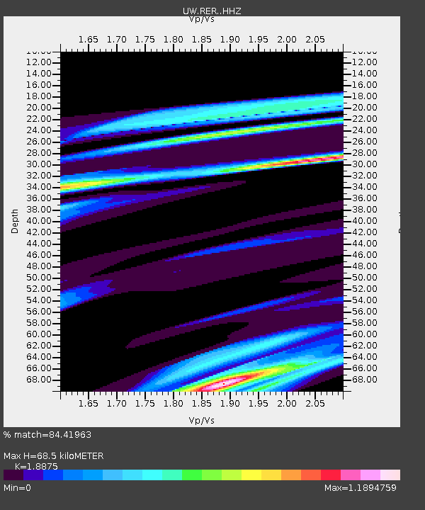
| Estimated Moho Depth: |
68.5 km |
| Estimated Crust Vp/Vs: |
1.89 |
| Assumed Crust Vp: |
6.597 km/s |
| Estimated Crust Vs: |
3.495 km/s |
| Estimated Crust Poisson's Ratio: |
0.30 |
|
| Radial Match: |
84.41963 % |
| Radial Bump: |
400 |
| Transverse Match: |
72.33243 % |
| Transverse Bump: |
400 |
| SOD ConfigId: |
33232451 |
| Insert Time: |
2023-12-16 16:28:14.561 +0000 |
| GWidth: |
2.5 |
| Max Bumps: |
400 |
| Tol: |
0.001 |
|

Signal To Noise
| Channel | StoN | STA | LTA |
| UW:RER: :HHZ:20231202T16:30:01.650027Z | 2.4161615 | 3.5528046E-6 | 1.4704333E-6 |
| UW:RER: :HHN:20231202T16:30:01.650027Z | 1.4587623 | 3.0846497E-6 | 2.1145663E-6 |
| UW:RER: :HHE:20231202T16:30:01.650027Z | 1.0184981 | 2.1441945E-6 | 2.1052513E-6 |
| Arrivals |
| Ps | 9.4 SECOND |
| PpPs | 29 SECOND |
| PsPs/PpSs | 39 SECOND |


