You are here: Home > Network List > IU - Global Seismograph Network (GSN - IRIS/USGS) Stations List
> Station GRFO Grafenberg, Germany > Earthquake Result Viewer
GRFO Grafenberg, Germany - Earthquake Result Viewer
| Earthquake location: |
Ecuador |
| Earthquake latitude/longitude: |
-1.3/-77.3 |
| Earthquake time(UTC): |
2010/08/12 (224) 11:54:15 GMT |
| Earthquake Depth: |
207 km |
| Earthquake Magnitude: |
6.4 MB, 7.1 MW, 7.1 MW |
| Earthquake Catalog/Contributor: |
WHDF/NEIC |
|
| Network: |
IU Global Seismograph Network (GSN - IRIS/USGS) |
| Station: |
GRFO Grafenberg, Germany |
| Lat/Lon: |
49.69 N/11.22 E |
| Elevation: |
384 m |
|
| Distance: |
90.0 deg |
| Az: |
40.483 deg |
| Baz: |
268.063 deg |
| Ray Param: |
0.041659128 |
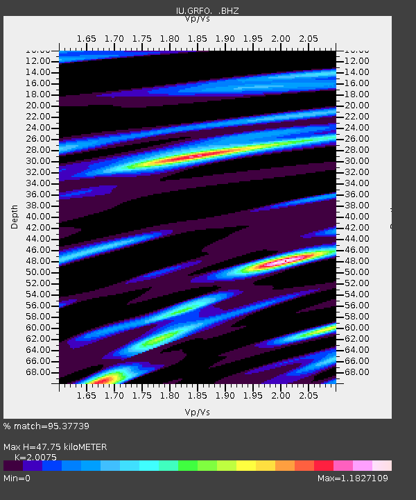
| Estimated Moho Depth: |
47.75 km |
| Estimated Crust Vp/Vs: |
2.01 |
| Assumed Crust Vp: |
6.182 km/s |
| Estimated Crust Vs: |
3.08 km/s |
| Estimated Crust Poisson's Ratio: |
0.33 |
|
| Radial Match: |
95.37739 % |
| Radial Bump: |
400 |
| Transverse Match: |
89.17524 % |
| Transverse Bump: |
400 |
| SOD ConfigId: |
319893 |
| Insert Time: |
2011-01-05 20:24:28.541 +0000 |
| GWidth: |
2.5 |
| Max Bumps: |
400 |
| Tol: |
0.001 |
|

Signal To Noise
| Channel | StoN | STA | LTA |
| IU:GRFO: :BHZ:20100812T12:06:20.170027Z | 50.543243 | 3.1889242E-6 | 6.309299E-8 |
| IU:GRFO: :BHN:20100812T12:06:20.170027Z | 7.1593513 | 4.641024E-7 | 6.482465E-8 |
| IU:GRFO: :BHE:20100812T12:06:20.170027Z | 22.368374 | 1.5124061E-6 | 6.76136E-8 |
| Arrivals |
| Ps | 7.9 SECOND |
| PpPs | 23 SECOND |
| PsPs/PpSs | 31 SECOND |


