You are here: Home > Network List > IW - Intermountain West Stations List
> Station IMW Indian Meadow, Wyoming, USA > Earthquake Result Viewer
IMW Indian Meadow, Wyoming, USA - Earthquake Result Viewer

| Earthquake location: |
Ecuador |
| Earthquake latitude/longitude: |
-1.3/-77.3 |
| Earthquake time(UTC): |
2010/08/12 (224) 11:54:15 GMT |
| Earthquake Depth: |
207 km |
| Earthquake Magnitude: |
6.4 MB, 7.1 MW, 7.1 MW |
| Earthquake Catalog/Contributor: |
WHDF/NEIC |
|
| Network: |
IW Intermountain West |
| Station: |
IMW Indian Meadow, Wyoming, USA |
| Lat/Lon: |
43.90 N/110.94 W |
| Elevation: |
2646 m |
|
| Distance: |
54.1 deg |
| Az: |
330.37 deg |
| Baz: |
136.864 deg |
| Ray Param: |
0.06495877 |
| Estimated Moho Depth: |
22.75 km |
| Estimated Crust Vp/Vs: |
1.84 |
| Assumed Crust Vp: |
6.207 km/s |
| Estimated Crust Vs: |
3.382 km/s |
| Estimated Crust Poisson's Ratio: |
0.29 |
|
| Radial Match: |
98.24545 % |
| Radial Bump: |
400 |
| Transverse Match: |
91.45177 % |
| Transverse Bump: |
400 |
| SOD ConfigId: |
319893 |
| Insert Time: |
2011-01-05 20:25:18.369 +0000 |
| GWidth: |
2.5 |
| Max Bumps: |
400 |
| Tol: |
0.001 |
|
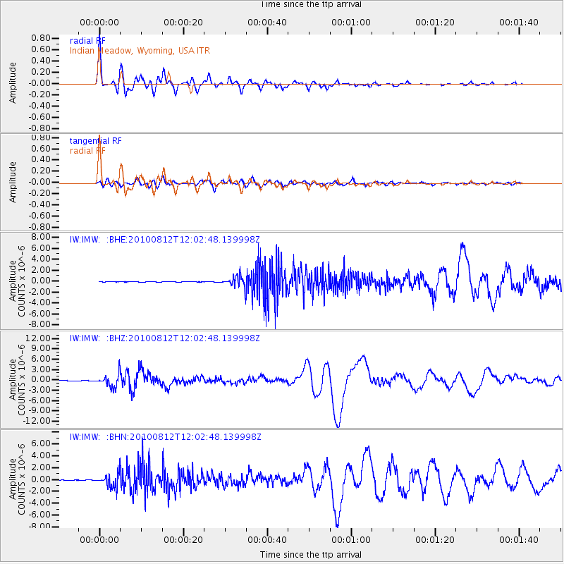
Signal To Noise
| Channel | StoN | STA | LTA |
| IW:IMW: :BHZ:20100812T12:02:48.139998Z | 44.29272 | 1.8582261E-6 | 4.1953307E-8 |
| IW:IMW: :BHN:20100812T12:02:48.139998Z | 39.12549 | 1.1287276E-6 | 2.8848905E-8 |
| IW:IMW: :BHE:20100812T12:02:48.139998Z | 28.04497 | 9.720949E-7 | 3.466201E-8 |
| Arrivals |
| Ps | 3.2 SECOND |
| PpPs | 9.9 SECOND |
| PsPs/PpSs | 13 SECOND |


