You are here: Home > Network List > LB - Leo Brady Network Stations List
> Station TPH Tonopah, Nevada, USA > Earthquake Result Viewer
TPH Tonopah, Nevada, USA - Earthquake Result Viewer
| Earthquake location: |
Ecuador |
| Earthquake latitude/longitude: |
-1.3/-77.3 |
| Earthquake time(UTC): |
2010/08/12 (224) 11:54:15 GMT |
| Earthquake Depth: |
207 km |
| Earthquake Magnitude: |
6.4 MB, 7.1 MW, 7.1 MW |
| Earthquake Catalog/Contributor: |
WHDF/NEIC |
|
| Network: |
LB Leo Brady Network |
| Station: |
TPH Tonopah, Nevada, USA |
| Lat/Lon: |
38.08 N/117.22 W |
| Elevation: |
1883 m |
|
| Distance: |
53.7 deg |
| Az: |
321.085 deg |
| Baz: |
127.273 deg |
| Ray Param: |
0.06519664 |
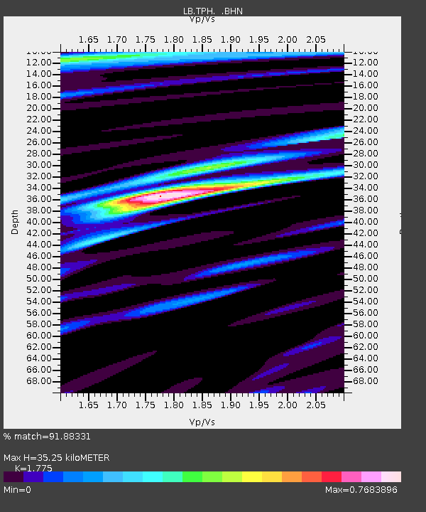
| Estimated Moho Depth: |
35.25 km |
| Estimated Crust Vp/Vs: |
1.77 |
| Assumed Crust Vp: |
6.276 km/s |
| Estimated Crust Vs: |
3.536 km/s |
| Estimated Crust Poisson's Ratio: |
0.27 |
|
| Radial Match: |
91.88331 % |
| Radial Bump: |
400 |
| Transverse Match: |
88.744255 % |
| Transverse Bump: |
400 |
| SOD ConfigId: |
319893 |
| Insert Time: |
2011-01-05 20:26:04.827 +0000 |
| GWidth: |
2.5 |
| Max Bumps: |
400 |
| Tol: |
0.001 |
|

Signal To Noise
| Channel | StoN | STA | LTA |
| LB:TPH: :BHZ:20100812T12:02:45.535994Z | 61.34763 | 2.714302E-6 | 4.424461E-8 |
| LB:TPH: :BHN:20100812T12:02:45.535994Z | 33.306248 | 9.098062E-7 | 2.7316382E-8 |
| LB:TPH: :BHE:20100812T12:02:45.535994Z | 19.580746 | 9.706614E-7 | 4.9572243E-8 |
| Arrivals |
| Ps | 4.6 SECOND |
| PpPs | 15 SECOND |
| PsPs/PpSs | 19 SECOND |


